What now?…..CROW BASIN and the Pioneer “YEEHAW TRAIL!”

WHAT NOW?   

On Thursday, August 1st, at NOON  I will be speaking at the monthly meeting of the Wyoming Historical Society at the County Museum in Evanston on:
“The TIE HACKERS:  Unsung American Heroes without whom the West might not have been won!”

 Then do research at Dubois, Lonetree, Burntfork, the Site of the 1st Mountain Man Rendezvous on the High Uinta’s Henrys Fk., then on to Manila and to the South Slope of the High Uintas in Vernal and the Uinta Basin.
Click here if you want to follow me…Spot Tracker Trail

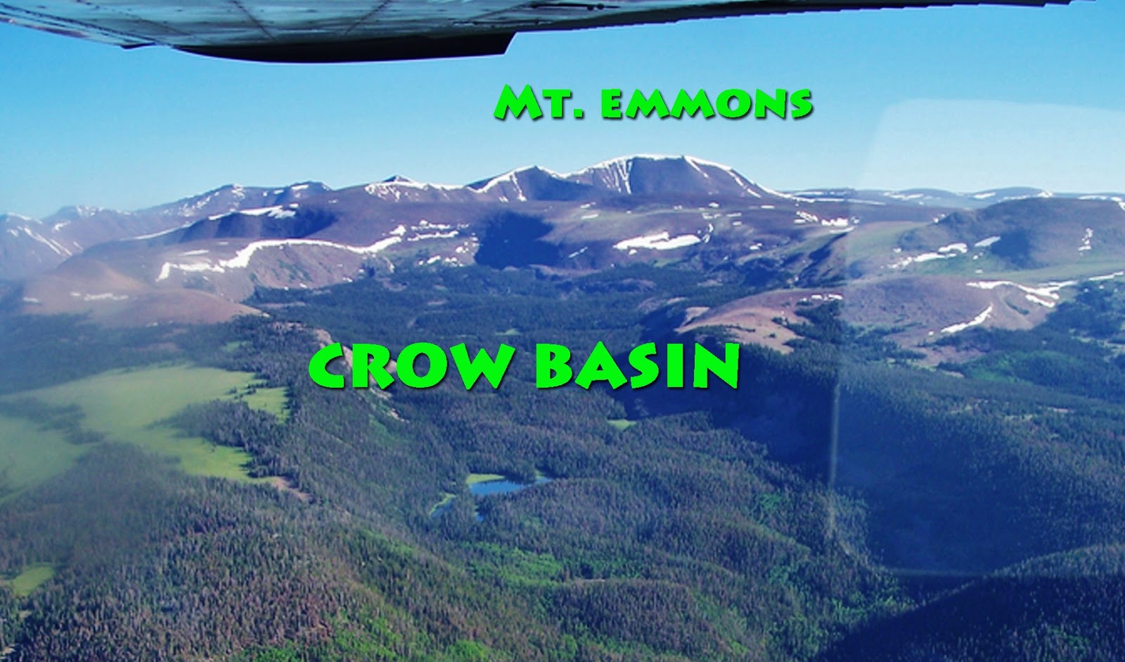
SCROLL DOWN FOR THE CROW BASIN ADVENTURE

Thankfully I withstood the “ACID TEST” and had one great backpack in the High Uintas Wilderness, now having explored all the drainages.  In my mind I did it in honor of the Utah Pioneers–for July 24th, and especially my great-grandmother, Alice Brooks (Andersen), survivor of the Martin Handcart Company.  As it worked out it was this  incredibly faithful and courageous 21 year old, and companions, who inspired me, in my 78th year,  to  
“NOT GIVE IN,”  rather pass the test and finally make it to CROW  BASIN.

This “historic YouTube video” is the CORRECTED, IMPROVED and ENHANCED version.

MUCH WAS EXPERIENCED,  and MUCH WAS LEARNED ENRICHING MY LIFE and I believe my YouTube video report will be WORTHWHILE FOR ALL–and you will meet 4 new HIGH UINTA FRIENDS.

For more information and great photographs of CROW  BASIN, plus some very valid opinions of one of the new High Unta Friends, Darren McMichael, go to his website at: http://www.outdooradventuresutah.com/

NOW THE ACID TEST…Crow Basin!…YouTube Video #2-2013 Exploring MYSTERIOUS MIDDLE FK of BLACKS FK and BOB’S LAKE

From July 19-24  I work on exploring CROW BASIN – part of the smallest drainage in the High Uintas between the Yellowstone and Uinta Rivers on the South Slope.

  I had to move the schedule ahead 1 day.  I will leave for Duchesne on Thursday the 18th, to consult with the Forest Service, and hope to be on the trail on the 19th and call KSL Outdoors Radio on the 20th to report my progress.

 If interested see the map and you can even watch the YouTube Video of my 2011 effort to get there.  You can follow me at SPOT tracking.    

 I will begin the exploration with an “OK” when I leave the car.  Thereafter I will end each day with an “OK”  when I set up camp, and at the end of the exploration when returning to the car.  If in the middle of any day an “OK” appears, it will be because of wanting to mark some special location.

Below is friend Jonathan Jaussi’s aerial photo of the area:

YouTube Video #3-2013 Searching for the Hilliard Flume Ghost

YouTube Video #2-2013 Exploring Middle Fork of Blacks Fork.  

See at the end a whole bunch of new incredibly beautiful and handsome HIGH UINTA FRIENDS


Sorry about the cover photo.   I wasn’t given much of a choice, but it is an interesting Google Earth view of one of the 14 tie hacker sites I found, mapped, photographed, measured and dated.  Learn more in this video about these touch guys without whom the West wouldn’t have been won!

MIRACULOUS SUCCESS WITH BACKPACK No.2–YouTube coming–NOW RESEARCH and EXPLORATION

VIDEO COMING…as soon as I get back to civilization and fast internet……in the meantime enjoy BOB’S LAKE and TOKEWANNA PEAK
Since coming down from Tokewanna Peak I have been doing very productive research in Mountain View, Lyman and Evanston, Wyoming, and now will be doing so in the NorthWestern High Uintas.  Follow me on the SPOT website clicking on the following link:  FOLLOW ME