Photo/Essay August 1, 2016
Just added 2/3rd thru a link to KSL PODCASTS & important discussion of
“High Altitude Sickness”
BACKPACK #2-2016 July 28-31
WEST FORK WHITEROCKS TRAILHEAD: The PLAN: To Cleveland Lk….Fox-Queant Pass (11,400 ft.)…upper Eastern Uinta River drainage to Brook & Divide Lakes…on to North Pole Pass (12,250 ft.) and down to Taylor & Queant Lakes….to Trailhead.
NOTE: This was to be sort of a test in my 81st year to see if my efforts to defeat a tendency towards High Altitude Sickness were working. All went fine during the Grandaddy backpack (#1-2016), but maximum altitude was only 10,700 ft. Backpack #2 would take me up to Fox Queant Pass at 11,400 ft. and if all went well, I’d go on to the 3rd highest pass in the Uintas–North Pole Pass at 12,250 ft.
LEFT EARLY July 28th Thurs. A “glitch” hit early on in Orem, hearing something was arriving at my cell phone. I pulled off to check, and found a highly important email from archaeologist friend, Garth Norman, inviting me to go on an “expedition” for 10 days to Guatemala and Southern Mexico. I almost made a U-turn right there, but contacted him about the dates which will be from August 9-18, then had to send a series of necessary emails changing future plans.
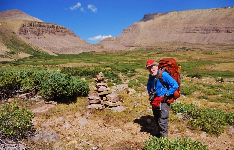
I finally continued towards Roosevelt in the Uintah Basin. From there drove up to the mouth of the Uinta River Canyon, and there turned onto the dirt Elk Horn Loop Road that took me up to the Chepeta Lake Road, and soon was at the Trailhead–167 miles from American Fork, Utah.

It took me a while to put my pack together only to find that I had too much weight, so did it again eliminating 5 lbs. and getting it down to 38 lbs. including my photography gear, sat phone, SPOT Tracker–but no tripod as I’ve learned to just set it on a rock or a log if I want to get into the action. Of course the satellite phone was provided by Russ Smith at Skycall Satellite & KSL Outdoors Radio. Since I just had to get backpacking again, it was necessary to renew my subscription for my SPOT Personal Satellite Tracker.
Here’s the information at the Trailhead. As you can see in the first photo, there are restrooms, but no water. You’ll have to do as I did, get it when you cross the bridge across the West Fork of the Whiterocks River a couple of hundred yards up the trail.
In the above map, we are on the right side of the dark green line to the left of which is the High Uintas Wilderness Area. Our first objective will be Fox Queant Pass which, as you’ll see is on the boundary line.
Didn’t look like too many adventurers were on the trail, but I’ve noticed that many don’t sign in. We all should for a lot of reasons.
All my water essentials are accessible carried in the large mesh stretch pocket on the back of my pack.
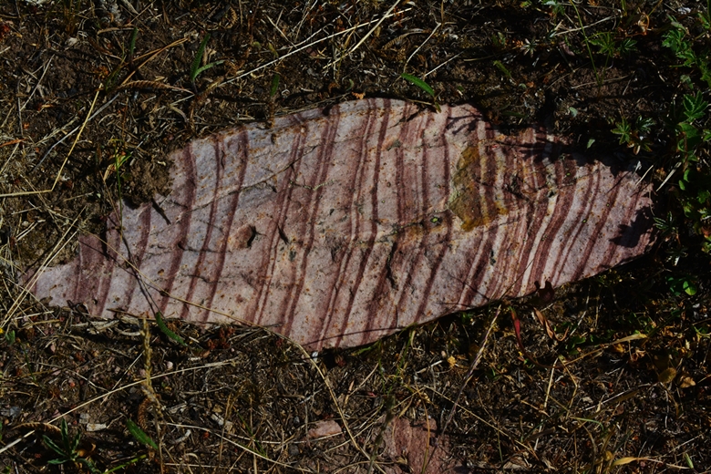
You will notice that I am constantly amazed by what I have variously called,
“The TEXTURES OF NATURE,” or “VISIONS of NATURE,”
which will be shared liberally throughout my report. You will be seeing these marvelous beauties of nature, as I was seeing them along the trail. This area in particular has many geologic wonders, showing the patient hand of the Creator, and His wavy artistic lines that never cease to awe me!
At first water, the West Fork of Whiterocks River, got my Gravity Works water purification system working for me. I’ve tried all the systems, tablets, boiling, pumping, & squeezing and none of them can even come close to touching the Gravity system….it does the work while you rest, eat, set up your tent, go fishing, etc.
This is the beautiful Fireweed flower. In my report I’ve got to hurry along so I won’t attempt to identify each flower, much less tell the geologic history behind each rock!
I haven’t been able to figure out what the difference is between the “backpacker” and “horse” trails. If I can find out tomorrow with Shiela at the Forest Service, I’ll insert it here.
WOW!
I didn’t intend to do a lot the first day, having left the Trailhead at 4:00 PM, so when I found a good spot to camp with water nearby I set up for a relaxing evening…..and hoped for less sore muscles the next day.
In the area found the bones of several cows…..and nearby droppings from coyotes. The coyotes obviously wouldn’t have had anything to do with the death of the cows, but would happily get what nourishment they could from the remains. I did hear coyotes yapping that night in the area.
A friend asked, “Aren’t coyotes dangerous to humans?” I replied, “Not unless you’re already dead–then they likely will happily have a great meal!”
I continued telling of two experiences when coyotes came close to the tent nosing around in some of my gear. I yelled at them and they were gone.
In the meadow nearby, I did jump a young buck.
The next morning I continued up the canyon.
As the trail began climbing a little more towards Queants Lake, there was an area with a whole series of what, in Guatemala, we would call “mounds” under which there would be ruins.
They are right out in the middle of the canyon and I’m quite sure they are piles of debris left by glaciers that formed these canyons many, many years ago.
“Hey, I know you! I met you on the Uinta River/Atwood Trail last year when you were having a bit of trouble with High Altitude Sickness.”
He was J.C. Batty and his companion Graham.
They seemed quite impressed that in my 81st year I was still doing my darndest to NOT GIVE IN…..EASILY!
They were on their way to Fox Queant Pass too, and from there would camp out at Fox Lake in the upper Uinta River Drainage.
J.C. said, as they headed up the trail,
“Maybe we’ll see you in a couple of days!”
PROPHETIC?…..see what develops at the end.
Soon I came to the junction, and took the left fork to Cleveland Lake.
The first ford…….of course me not having as steady a balance as I used to have, looked for another crossing, and soon found one, part of it what had been a bridge many years ago.
Pretty soon I had to cross another stream and ripped a dead branch off of a tree, and broke off its branches, to steady myself as I crossed as at my age one has to be real careful.
I was resting a bit when three young fellas came up the trail from Cleveland Lake, and….of course we got talking about my High Uintas Wilderness Project that I’m now beginning to put together.
They are….likely not in order: Creedon,Treavor and Lance.
They seemed a little surprised that an old guy in his 81st year would be backpacking still, so I told them what the objective is:
“Be 80+, look like 60, perform….no, I mean, behave like 30, and weigh like when I was 20!”
And….this “texture of nature” will be turned into something unique!
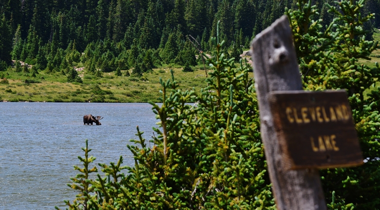
Soon I came to Cleveland Lake, with 12,514 ft. Cleveland Peak in the left background, and in the right center Fox Queant Pass.
Part way around the lake we come to the sign….but see off to the left in the middle of the lake….something? Let’s change our focus…..
Sure enough it’s a bull moose. Obviously Cleveland lake is for the most part quite shallow with the moose feeding on water weeds.
I wanted to camp some above the lake to get a good start the next day, but just had to test the waters for fishing as the three young men I had just talked to said the
“FISHING WAS GREAT!”
It was very windy but I was able to cast my small Colorado Spoon pretty good and on the first cast caught a nice brook trout, and proceeded to catch others on almost every cast, and while doing so another bull moose appeared across the lake.
The brookies weren’t very colorful….at least not like the ones from above timberline Porcupine Lake in the Oweep Drainage….I’ll insert one of them below….
Finally I moved on to look for a good camping spot up above the lake.
Apparently I had intruded on the territory of a couple of does, who kept circling around my camp……..
They persisted fooling around with a couple of things I left out….like my pot that was in its fabric bag….the bag, pot and lid scattered during the night.
Saturday morning up early and gave my satellite phone report to
KSL OUTDOORS RADIO
There were a couple of minutes of report…then lost the signal, Tim & Russ continued another few minutes talking about the High Uintas Project with some ineresting comments.
To listen click on the following: PODCAST ….my report begins at about the 10 minute point, but continues a great segment on….
HIGH ALTITUDE SICKNESSA case of this problem, interviewing an experienced backpacker between 55-60, talking as though that was “old,” is discussed in the first hour of the Podcast with the above link. It is continued, describing the helicopter rescue, and importantly THE LESSONS LEARNED, in the 2nd hour at the following link: 2nd hour PODCASTTHIS IS A CRUCIAL SUBJECT ALL BACKPACKERS SHOULD UNDERSTAND & THESE TWO PODCASTS DO A GREAT JOB EXPLAINING IT….…….PAY ATTENTION!
Soon afterwards I began my routine to get ready to head for the pass.
FALSE DANDELION….this is not “the spinach of the weed world.”
That morning, the 3rd day, soon saw me on my way towards the pass, but met coming down, Rick & Cassidy Frost, and Lynn, Trevor and Daxton Zubeck.
Then, while filling up with water for the assault on the pass, met another couple of new High Uinta Friends: Bruce Hall and Randy McKnight
They had backpacked to Fox Lake & area…but had no backpacks! Apparently while resting a bit earlier, Bruce’s son had passed me going down the trail….carrying their camping gear!
WOW…WHAT A SOFT DEAL!

There were others seen on the trail, mostly on horseback–including one group with about 10 horses and pack mules, but I only met and talked to those shown in this report. One thing that I saw among almost all of those I met, and others just seen, is that most were armed with pistols or revolvers, and on asking didn’t’ get a reply concerning bears, rather mountain lions.
In the discussions I did get to tell the story of the bear attack on Josh Christensen in 2001 in the Lake Fork area between 9,500 and 10,000, and explained that on my backpacks above 10,000 feet I didn’t worry about bears–none of which I’d ever seen in all my thousands of miles of backpacking in the High Uintas, but that I had once seen a cougar on an elk hunt in the Uintas. I went on to explain my two warning shots fired with my Colt .45 Defender were: Once to scare off a mama moose who came after me, and another time to keep a Charolais bull from charging.

Now I seriously have in view the pass, and soon will be above timberline.
By the way, what you see veering off to the left is THE TRAIL!
Can you see it? THE TRAIL GOES RIGHT UP THE CENTER OF THE PICTURE!
Apparently it isn’t easy for the horses either with debri along the trail.
WOW!
We are now half-way there. I keep grinding away, carefully as at my age, and especially being alone, I can’t afford to make a mistake!
Hallaleja!
Made it to FOX QUEANT PASS, 11,400 ft. with
The HIGH UINTAS WILDERNESS boundary signs.
Yes, I really did make it…..even though I have to admit that I didn’t feel all that well, with just a hint or two of the altitude affecting me some.
So with that feeling of caution, and also storm clouds that were gathering and lightning and thunder heading my way, I decided it wise to not proceed into the Uinta River Drainage and the much higher North Pole Pass, at 12,250 ft. 3rd highest in the Uintas.
If I had of known this would happen, I could have left my camp set-up back at Cleveland Lake and without my backpack just bagged this pass with a “Day hike.”
And, wouldn’t you know it….I found an old favorite friend/flower
OLD MAN OF THE MOUNTAIN
Notice the wind blowing pretty strong.
This is the view looking northwest towards the Uinta River Drainage, with Fox Lake in the center.
This is the view looking southeast, where I had come from, the West Fork of the Whiterocks Drainage.
I bid farewell to my friend, OLD MAN OF THE MOUNTAIN, which is beginning to wither and finish its life cycle for this year, so I begin my descent, carefully. The storm clouds were getting more menacing.
Once down into the forest the rain came pretty hard and I kept moving protected some by my poncho, and got down to Cleveland Lake on this the 3rd day, but…… it didn’t look like what you see……rather the sky was black, and drops of rain were beginning to fall again.
I had to quickly find a spot to camp in the protection of the forest, and set up my tent as the rain was falling, not much fun when raining….and crammed inside what I needed, and put my pack in the small vestibule, and crawled in just as the rain really began pouring down along with earth shaking with thunder & lightning…all of which continued most of the night.
No hot meal, just some munches…actually for the whole day since a granola/raisens/dried bananas/egg nog breakfast, and not much water….but enough to swallow my supplements and get me through the night.
In the morning the rain stopped for a while and I packed up my wet gear–also not much fun, and got on the trail, moving a couple of miles–only stopping to fill my water bladder. Then, when the rain was about to begin again and I stopped to rest and get out my rain gear, determined to persist to the Trailhead…….
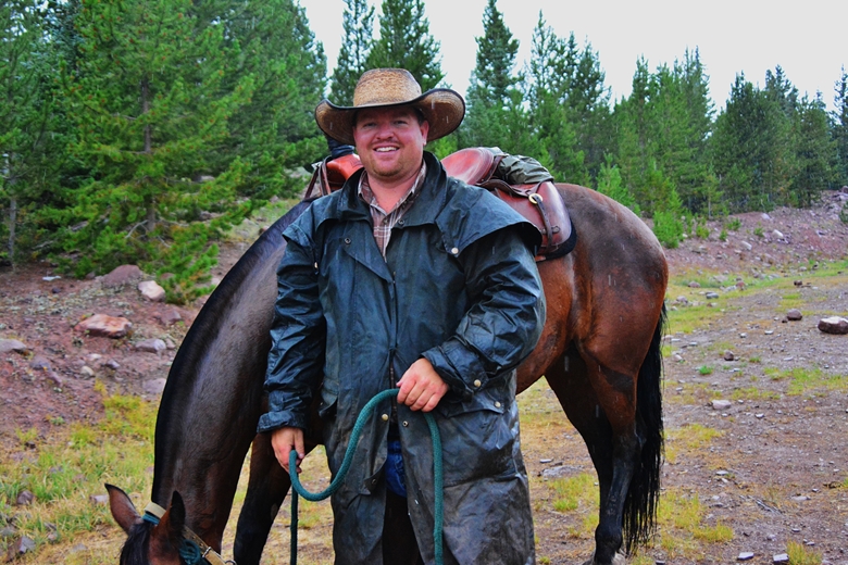
…..but who should appear?
J.C. and Graham had come from Fox Lake that morning. J.C. said,
“We’ll get to the Trailhead, and then I’ll come back for you!”
I thanked him, and told him I’d move in that direction as fast as I could….we estimated maybe 3.5 miles to the Trailhead.
In the next little while I did 2 miles in the rain, when J.C. arrived with my trusty steed, “SHIMMER!”
J.C. helped a sort of inflexible old cowboy up into Shimmer’s saddle. J.C. took my pack across his saddle, and off we went as the rain started again.
As we jostled down the rocky trail, I told J.C. my “John Wayne” history from 66 years ago when as a young Boy Scout I’d gone with a friend, Dick Johnson, to get his Horsemanship Merit Badge. The counselor asked “Are you both here to get it?” Dick spoke up and said, “Yes!”
I was about to panic as I knew next to nothing. She started the questions, and when I could….. I spoke up quickly, like as though I knew something. Dick answered the rest, making us together seem like we were experts!
Then to the riding ring to test our horsemanship skills. Dick did great, then it was my turn and I wanted to disappear……but my Dick, being a lot taller than me, had the stirrups very long–each of my legs about 12 inches too short– so we would have to adjust. The counselor spoke up, and said,
“Let’s not waste time doing that. BOTH OF YOU PASSED!”
Now, 66 years later, came MY ACID TEST IN THE RING OF LIFE!
J.C. laughed at my John Wayne story, and just said,
“JUST HANG ON AND DON’T FALL OFF!”
Graham was waiting for us at the Trailhead, and inspite of the rain jumped out of the pickup to take a picture of me on Shimmer.
As soon as I get that picture I’ll insert it here along with my buddy, John Wayne.
NOTE: Never got the picture….Graham’s smart phone lens likely obstructed with a drop of rain!
NOW HOPEFULLY OFF TO THE MYSTERIOUS JUNGLES OF GUATEMALA & SOUTHERN MEXICO………
…..”In search of verifying another really important dream more than 50 years in the making!”
NOTE: As it worked out, my trip to Guatemala/Southern Mexico will now likely be in October, but I was asked by the archaeologist to remain in civilization “on call” in case he needs me in which case he’ll email me a ticket to fly down the next day.
………and before the summer is over on to…..
LITTLE ANDY LAKE!
***********