Update Wed. Feb. 23, 2022 – MY “COMEBACK STATUS” — Exploring the “GRANDADDY” of all trails in the High Uinta Wilderness, “THE HIGHLINE TRAIL” & nearby areas/lakes: This week: WINDER, WYMAN & PACKARD LAKES & a grand view of the DUCHESNE RIVER CANYON — FLOWERS to trigger SPRING — And, last a link to a 1 page WRITING to UNDERSTAND — “MY LIFE AMONG THE MAYANS,” plus FREE DOWNLOAD link for FINISHED BOOK —

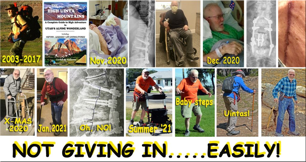
The back surgeon, “SOMETHING HAS TO BE DONE….OR YOU’LL END UP IN A WHEELCHAIR!”

THE DANGERIOUS MISALIGNMENT OF MY SPINE!

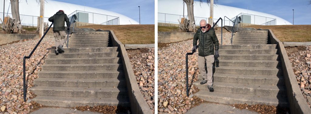
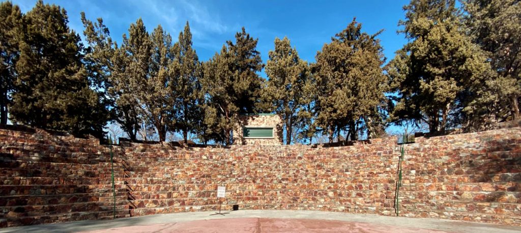
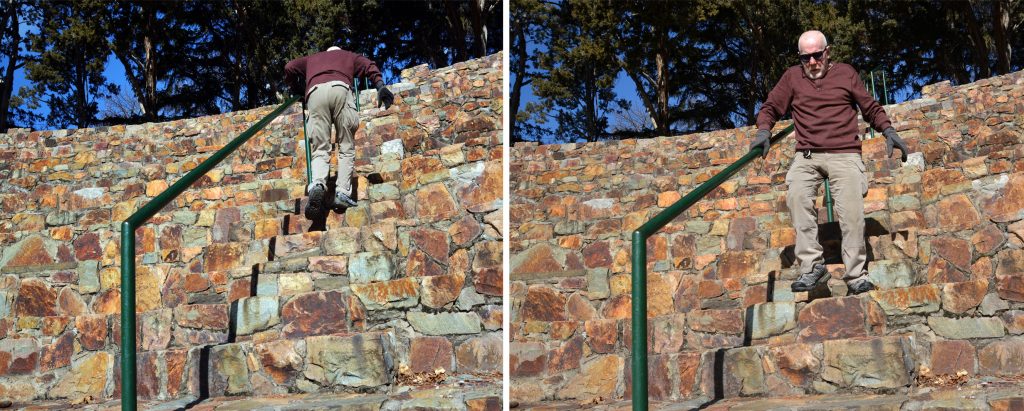
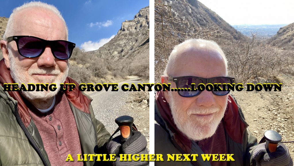
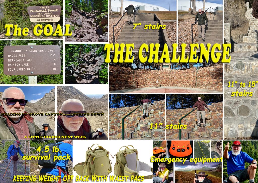
“The surgery could take 6 hours, followed by days in the Intensive Care Unit, and more in the hospital. I’ve never done it with an 86 year old person, and there could be complications. If you don’t do it, you’ll have to stop all your exaggerated COMEBACK effortsstairs behind Fitness Center, higher stairs at the Amphitheater, long hikes with your walker, hikes up Grove Canyon which for the first time in my life with a patient, has me wanting to hit you with a doubled up fist!” –showing me his HUGE DOUBLED UP FIST!

“But Doctor, without all my exercise program and goal of backpacking this summer, in just a couple of days I begin feeling awful!”

He then asked, “DO YOU WANT TO BE PARALYZED OR DEAD?”

I replied, “For me, best continue with my goal, and exercises and feel good….risking being DEAD!” He gave me a couple of days to let him know.

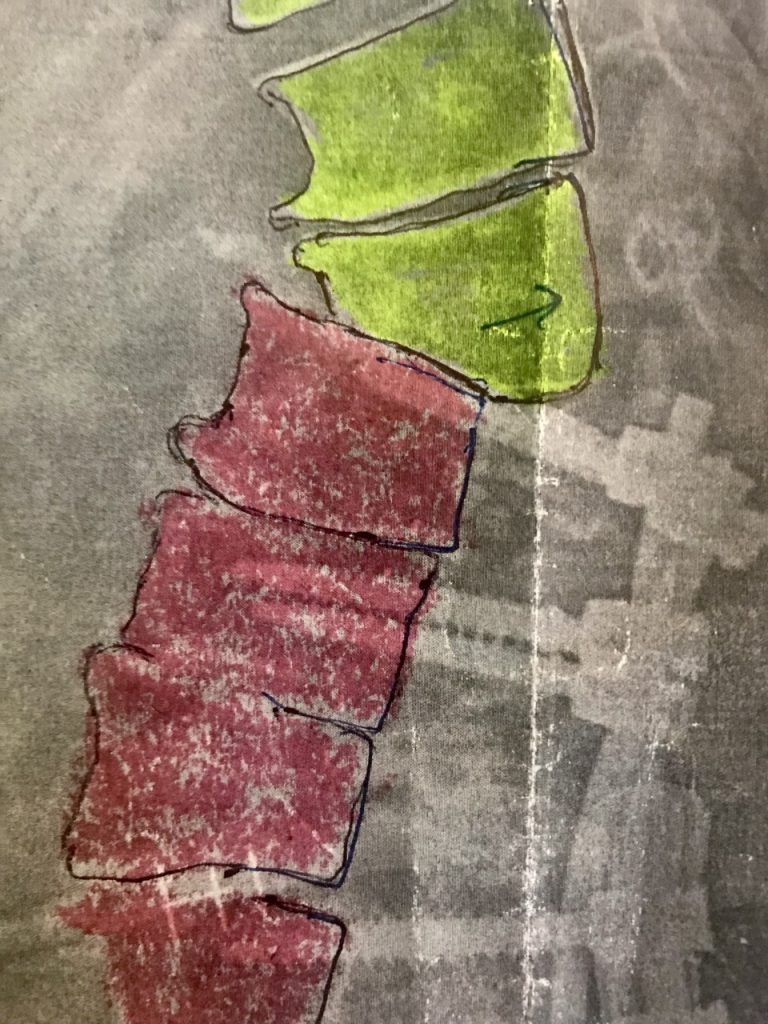
So I immediately called my HIGH UINTA FRIEND, a spine specialist who took his wife on their honeymoon backpacking to Red Castle, and last year using my HIGH UINTA BOOK as guide they did the 856 mile auto-loop tour of the Uinta Mountains, and HE RAVED ON, AND ON ABOUT THAT WONDERFUL EXPERIENCE! He gave me immediately an appointment, took X-rays, and we looked at my spine history giving me 3 copies of X-rays: Jan. 28, 2021=no misalignment so my falls weren’t guilty;

Oct. 2021=the X-ray above showing the dangerous misalignment that happened gradually during my exaggerated hikes during the summer hovering over my walker for 2, 4, 6, 8, 10 miles and up to 13.2 miles, a half-marathon distance-those hikes hovering over my walker for up to 6-7 hours apparently hurt my spine;

And the X-ray the day of my clinic visitwith spine misalignment looking the same, so my recent exercise program hasn’t hurt me so I could continue with MY GOAL….MY CHALLENGE!

HERE YOU CAN SEE MY GOAL–MY CHALLENGE, to actually WORK ON GETTING STRONG ENOUGH TO BACKPACK SOME IN 2022 & BE CAPABLE OF MANUEVERING DANGEROUS ROCKY STRETCHES YOU SEE IN THE MONTAGE ON THE HADES/GRANDADDYTRAIL……all by doing DAILY THE 7″ STAIRS TO WARM-UP, THEN TO THE AMPHITHEATER TO DO THE 11″ STAIRS, and WEEKLY A CONTINUALLY LONGER HIKE UP GROVE CANYON. EVENTUALLY DOING DAILY THE HIGH STAIRS ON THE RIGHT, BUT SINCE THERE’S NO HAND RAIL, USE MY TREKKING POLES. AS THE SUMMER APPROACHES BEGIN CARRYING A LOAD WITH ONLY 4.5 lbs. ON MY BACK, THE REST, IN WAIST PACKS, BUT USING EXTREME LIGHTWEIGHT BACKPACKING TECHNIQUES–and for the ACTUAL BACKPACKS OBSERVE ALL MY SURVIVAL PRECAUTIONS FOR WHICH I WILL NEED MY OLD BUDDY, RUSS SMITH & SKYCALL COMMUNICATIONS……DID YOU HEAR ME, RUSS?

So we concluded that it was best to not do the surgery, but carefully keep up with my COMEBACK PROGRAM, gradually increasing the repetitions and get X-rays every 3 months to make sure all continues SAFELY. I WAS SO HAPPY I ACTUALLY SHOUTED! THEN FOR THE FIRST TIME IN 3 DAYS WENT & DID MY STAIRS & SOON WAS FEELING A LITTLE BETTER!

THIS PHOTO I USE TO OPEN MY WEBSITE WAS TAKEN ON MY FIRST MAJOR BACKPACK JUST AFTER THE CORRECTIVE SURGERY ON MY “FOOTBALL ANKLE“–
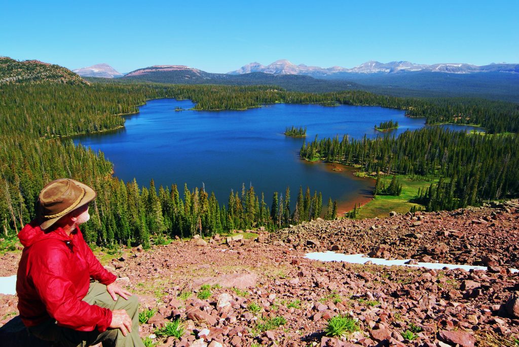
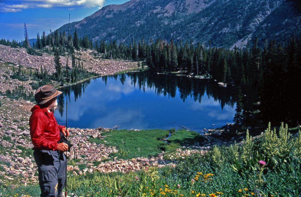
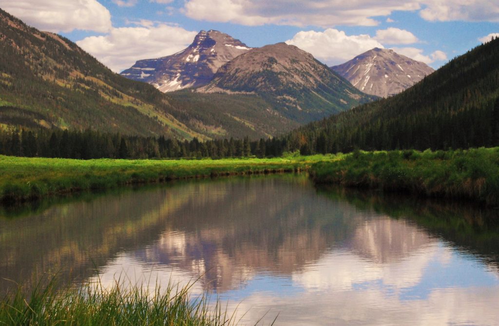
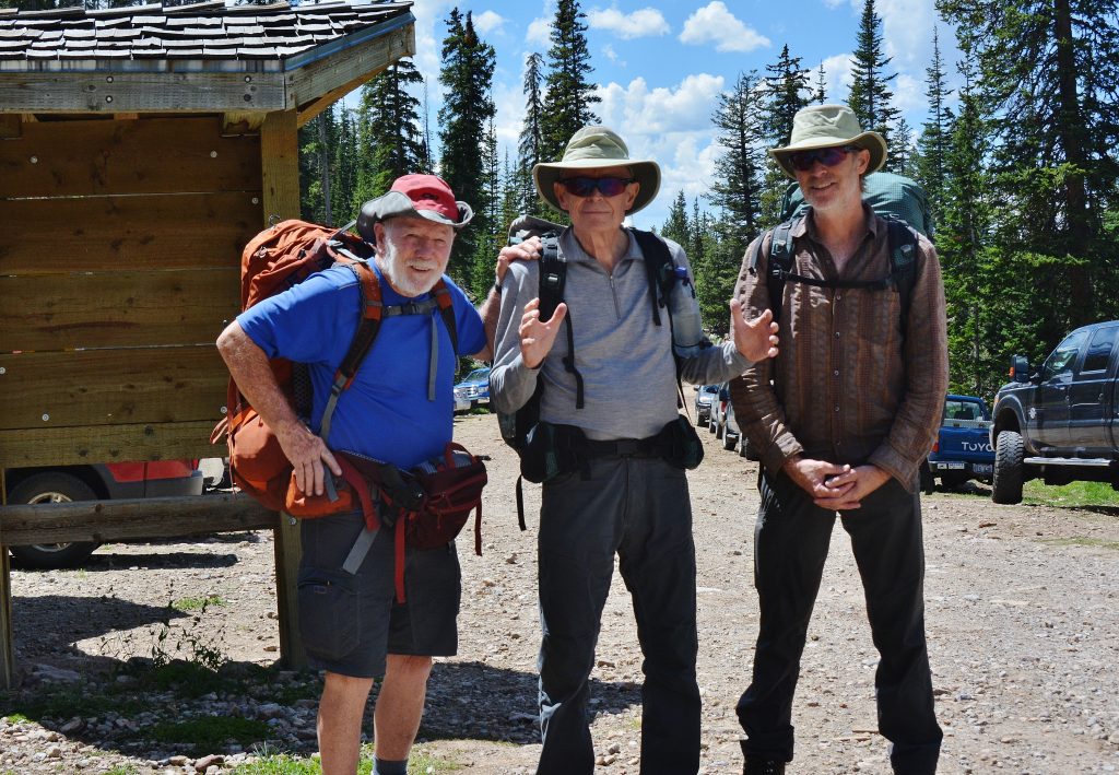
I got deservedly against West High School in 1953 after I had made a dirty play–my first & last– that got one of them carried off the field, then my next pass was intercepted they going 80 yards for a touchdown to beat us. Then I received the kickoff, went down the middle of the field through a V-shaped blocking scheme, got to the 30 and hit but spun around and made it to the 40 when the whole West High team took me out and I was carried off the field–ending my dream of the NFL and had me limping around the “Mountains of the Maya” and “the High Uintas” until 2007 with the surgery–then I side-stepped up East Grandaddy Mountain to get this photo.
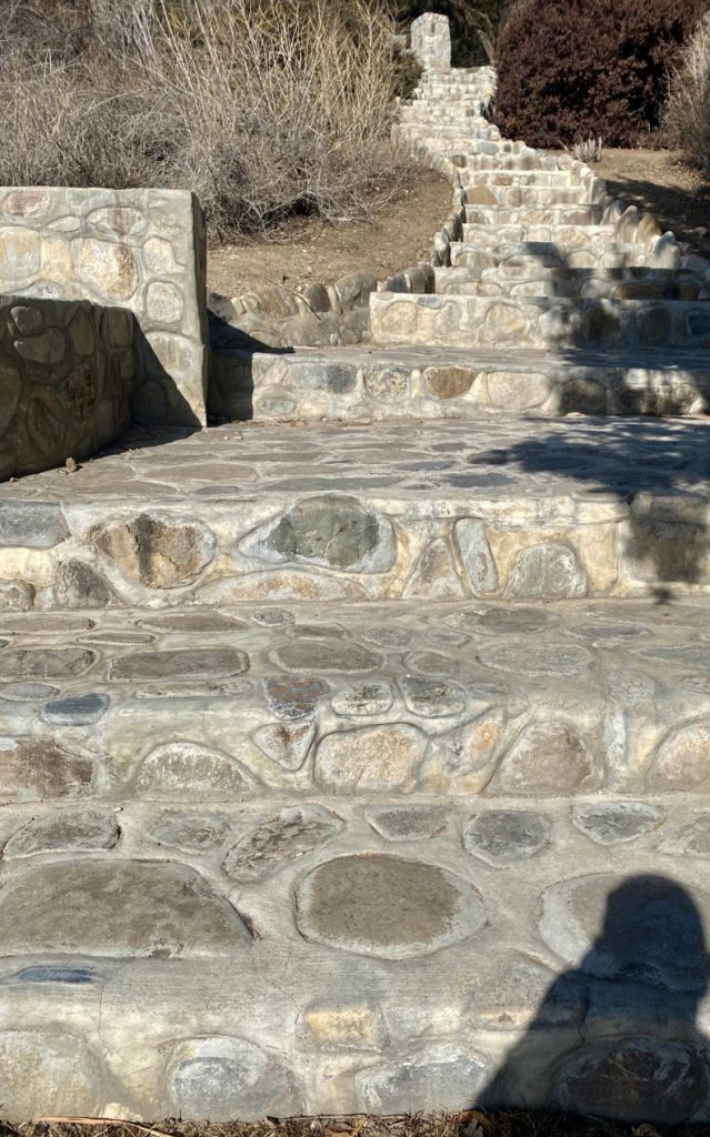
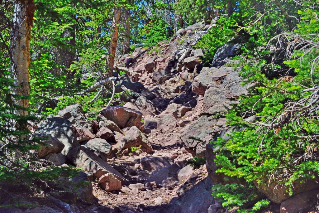
I WAS LIMPING & CLIMBED UP HERE FOR THIS SPECTACULAR SHOT BY SLOWLY “SIDE STEPPING” WHICH I CAN DO AGAIN TO GET THROUGH TOUGH STRETCHES OF ANY TRAIL LIKE WE SEE BELOW. i WILL BE SO SLOW ANY COMPANION WOULD GO CRAZY, SO UNDOUBTEDLY I’LL BE ALONE–AGAIN–AS I HAVE BEEN ON MOST OF MY 2,000+ MILES OF BACKPACKING AS NO ONE IN THEIR RIGHT MIND WOULD WANT TO RISK “GOING NUTS” TO DO IT LIKE I HAVE TO–“MY WAY!”
THIS IS THE MOST DIFFICULT STRETCH OF THE HADES PASS GRANDADDY TRAIL–I WILL HAVE TO SIDE-STEP UP TO GET ONE MORE TIME TO “THE GRANDADDIES!”

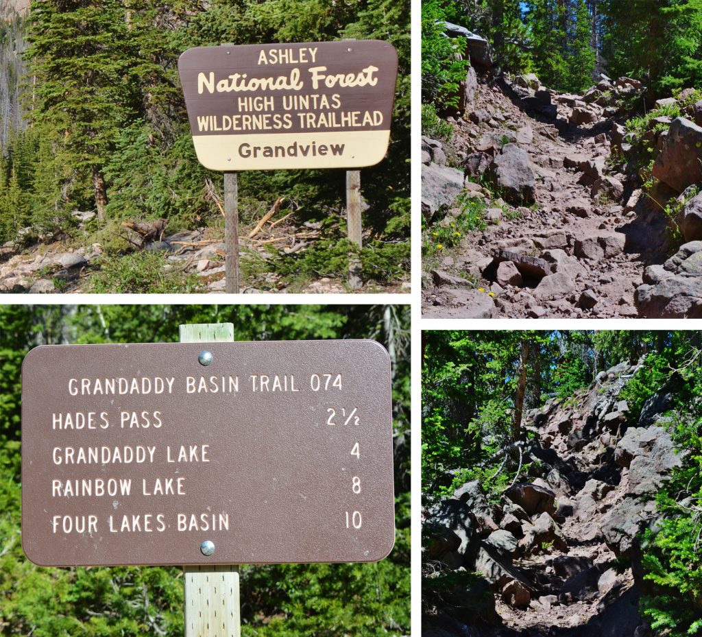
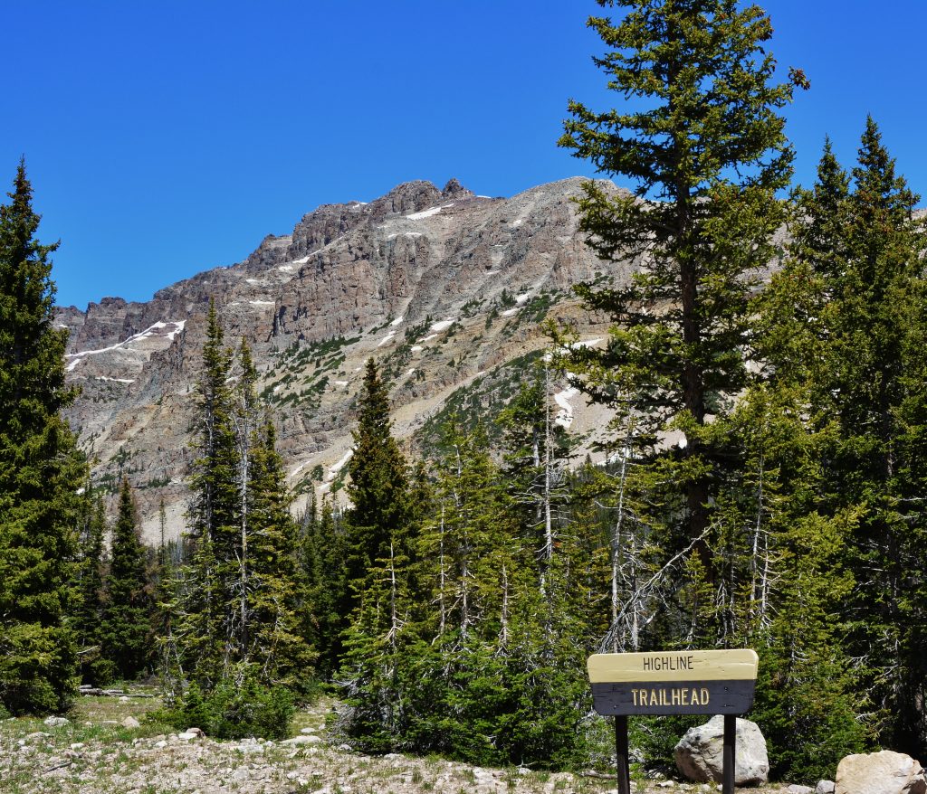
THE “GRANDADDY OF ALL HIGH UINTA TRAILS”

THE HIGHLINE TRAIL

This trailhead is found along THE MIRROR LAKE SCENIC BYWAY, 34 miles northeast of Kamas, Utah. The trail heads east following the spine of the Uinta Mountains going over 6 passes in the Wilderness Area. At 60 miles it crosses the first road at the Chepeta Lake Trailhead, and then at 76 miles crosses another road at the Leidy Peak/Hacking Lake Trailhead. From there it continues east 26 more miles to the end of the trail near U.S. Highway 191, 102 miles from the beginning of the trail. At that point you are near Flaming Gorge Dam.

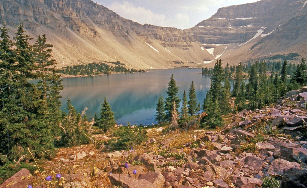
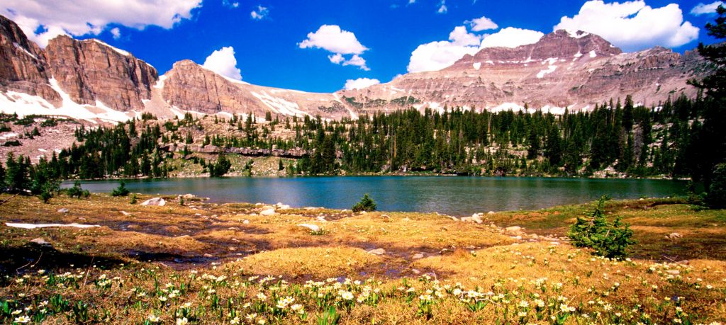
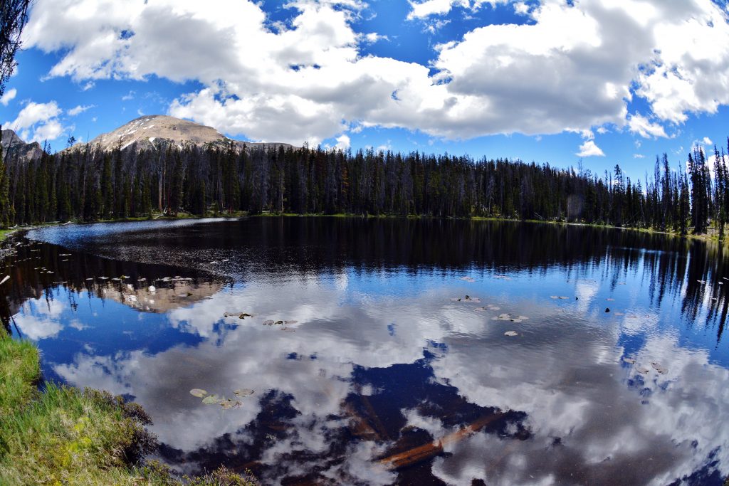
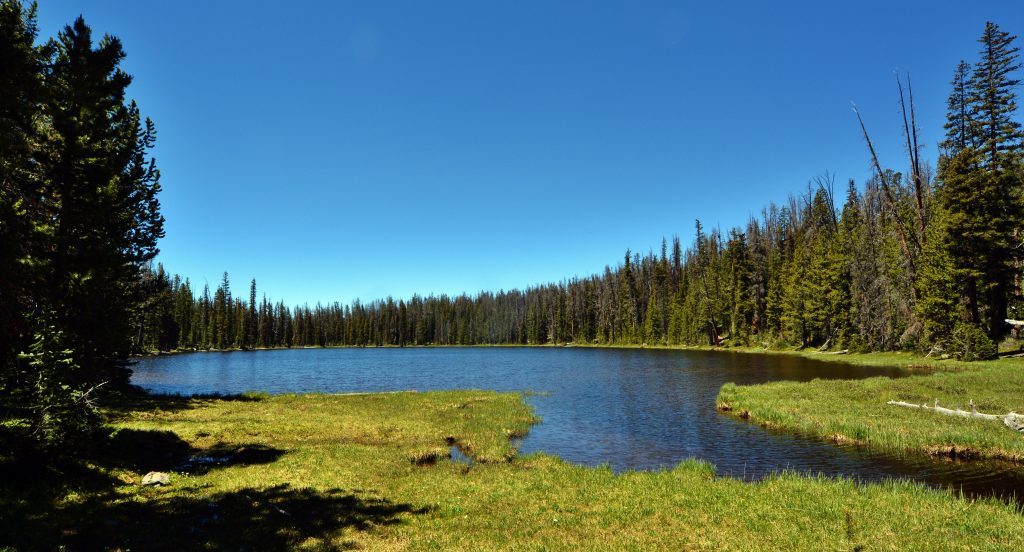
AFTER HEADING EAST ON THE HIGHLINE TRAIL — the first lake you pass by–the trail passes by above the lake–is Scudder Lake, seen below, but it does not have fish–at least it didn’t have in 2014 when this wide-angle picture was taken.

The closest lake from the Trailhead, with a population of trout, is WILDER LAKE – From the Highline Trailhead you hike 2.5 miles and come to a sign pointing south to Wilder, Wyman and Packard Lakes. Information on these lakes and the hike is found on pages 162-163 of my book.

WILDER LAKE AT SUNSET WITH MT. AGASSIZ IN THE BACKGROUND

The next lake down this trail, a 1/4 to 1/2 mile, is WYMAN LAKE

WYMAN LAKE is stocked with eastern brook trout but has a tendency to winterkill.

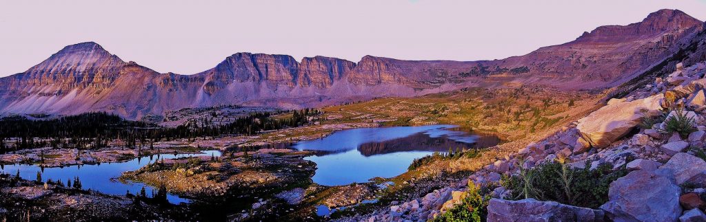
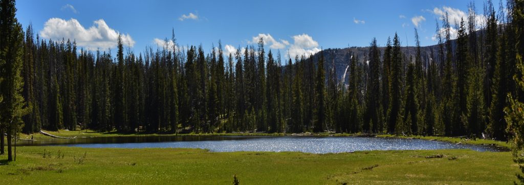
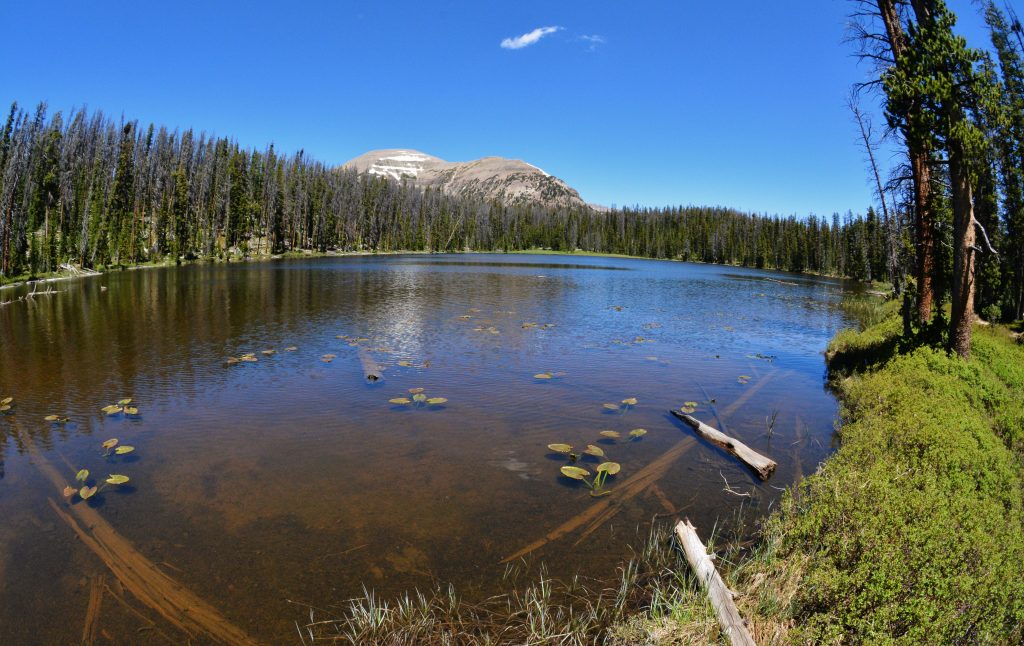
One quarter of a mile down the trail from Wyman Lake you come to the largest lake of the three that has a nice population of eastern brook trout that tend to be larger than in the other lakes. It is Mt. Agassiz that we are seeing in the background.

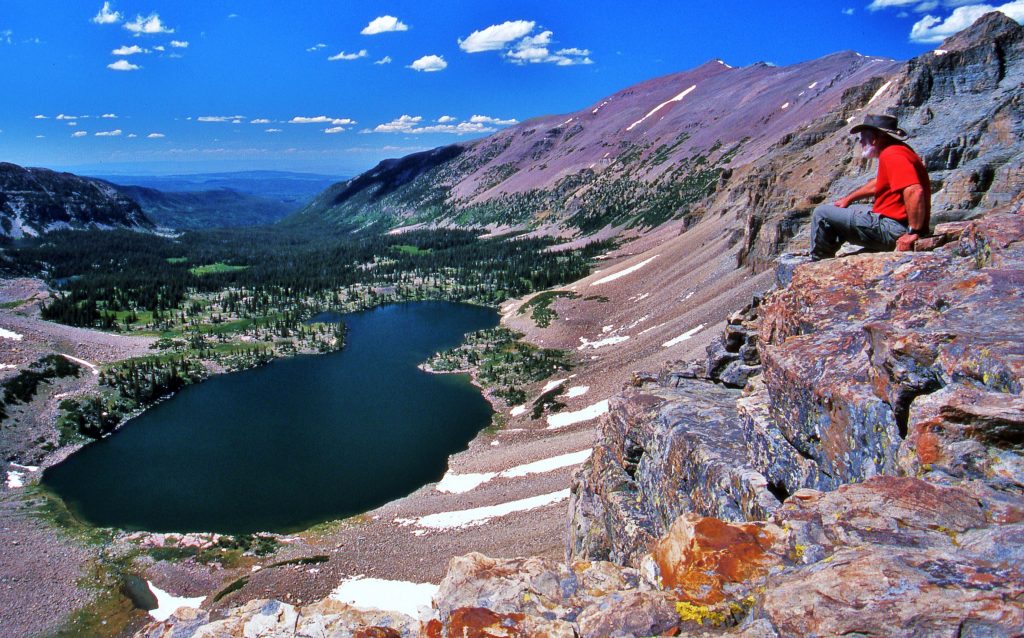
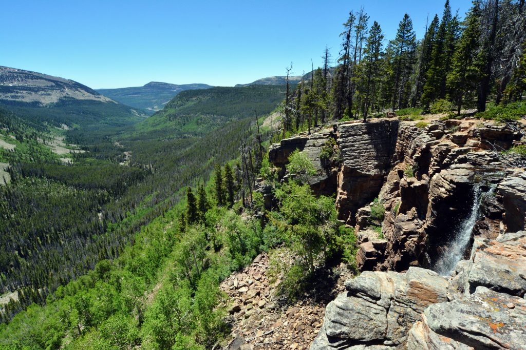
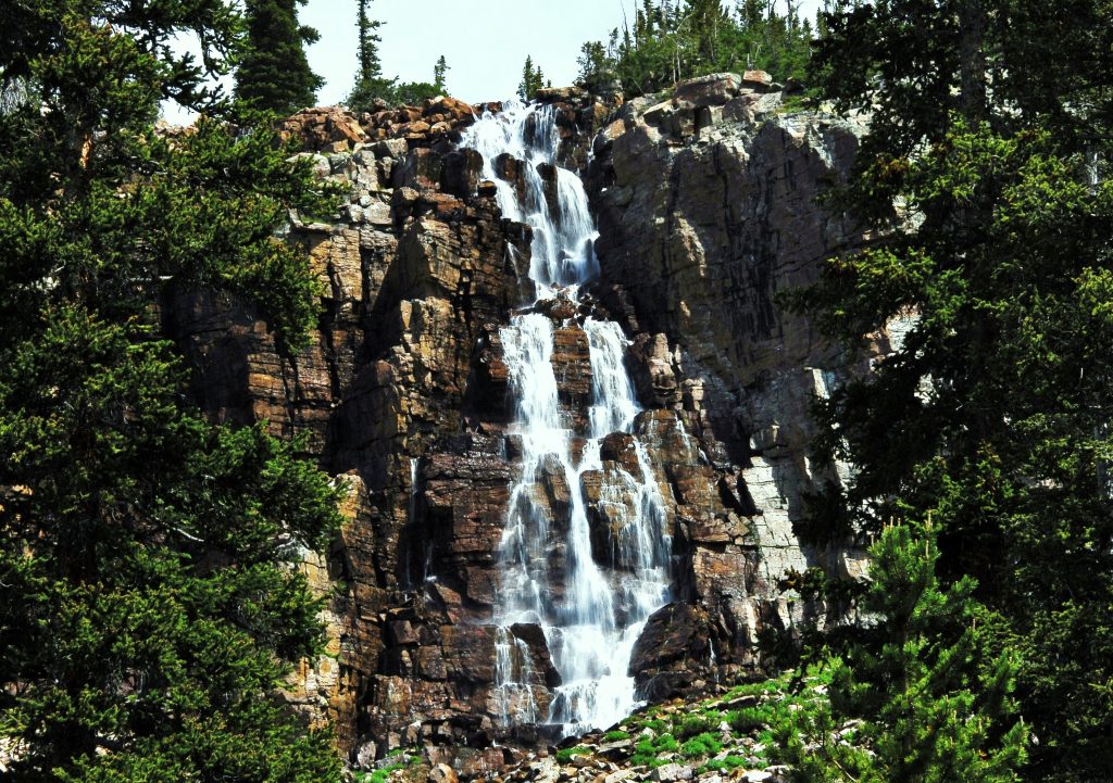
While at Packard Lake, don’t fail to follow the outlet stream just 50 yards or so to view the Canyon of the Duchesne River I’ll insert a couple of pictures of.

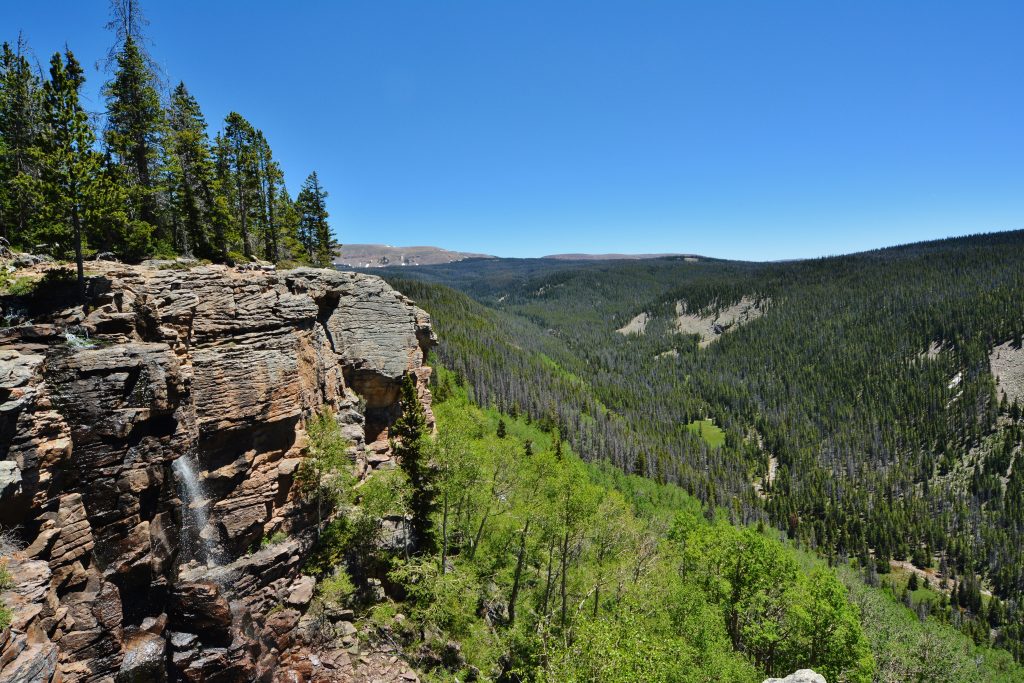
We are here looking northeast. We’ll now swing around and look towards the south where downstream is found Defa’s Dude Ranch, and the road up Hades Canyon to the Grandview Trailhead–THE GATWAY TO THE GRANDADDIES.

OUR NEXT POST WILL CONTINUE ALONG THE HIGHLINE TRAIL TO THE NEXT TRAIL THAT WILL TAKE OFF TO THE NORTH TO VISIT THE NATURALIST BASIN.

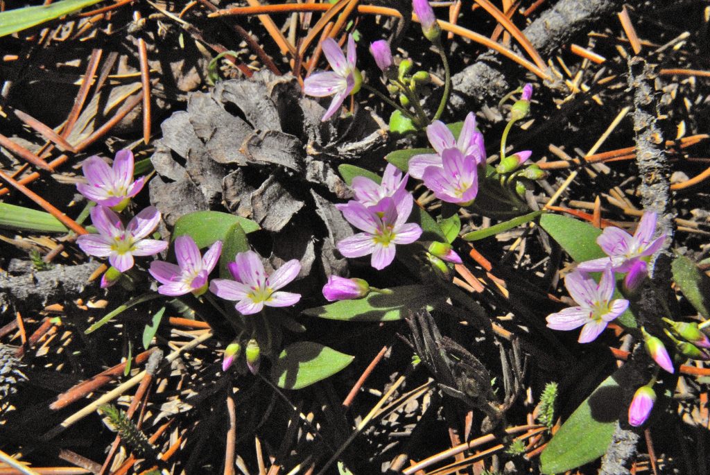
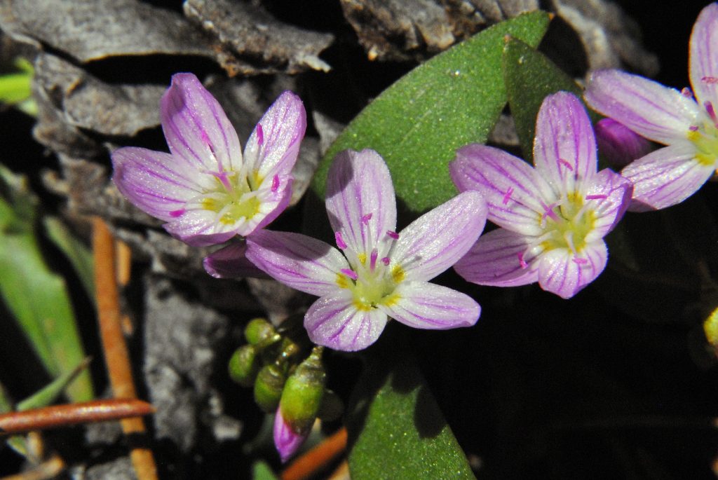
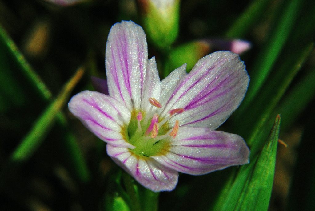
WILD FLOWERS TO TRIGGER SPRING

From her on, once a week or so, I’ll begin inserting a WILD FLOWER of the over 317 varieties I have documented in my explorations — from the Foothills to KINGS PEAK.

This week, one of the first to blossom in the high country:

SPRING BEAUTY, Claytonia lanceolata

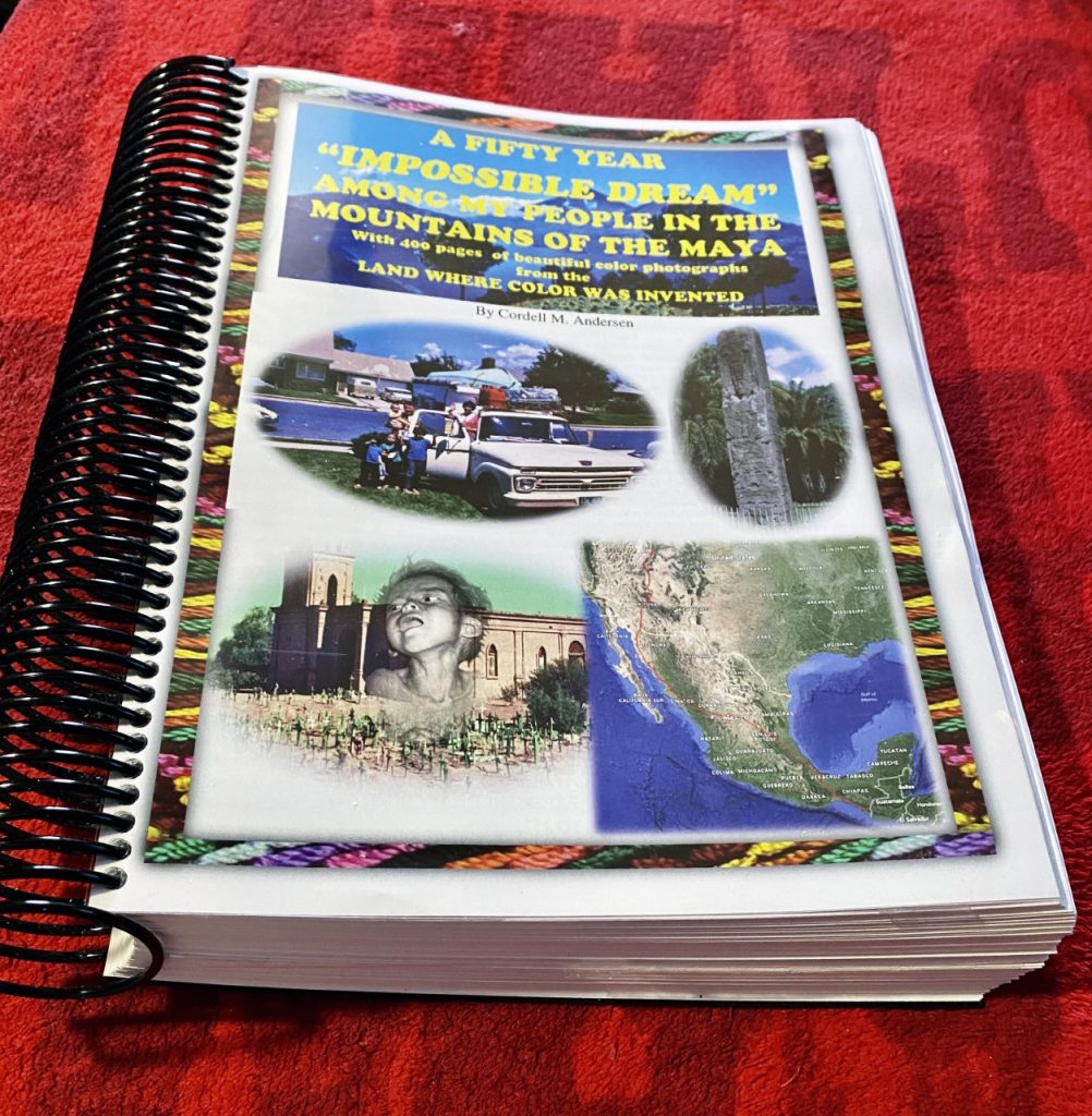
NOW JUST A WORD OR TWO ABOUT THE TWO BOOKS THAT TELL THE STORY OF MY LIFE–for which I’m most grateful, FIRST what some are calling

THE ENCYCLOPEDIA OF THE HIGH UINTA MOUNTAINS:

To get an online copy of this book, some have called THE ENCYCLOPEDIA OF THE UINTAS, send me $20 (don’t be afraid of sending a $20 bill as we aren’t south of the border) along with your email address, and I will immediately email you the link to download the book with my permission to share once with a friend. Send to: Cordell Andersen, 444 Elm St., American Fork, Utah 84003
FOR THIS BOOK THAT TELLS THE STORY OF MY LIFE-LONG LOVE AFFAIR WITH THE MAYAN PEOPLE, I’LL INSERT THE FIRST PART OF THE OPENING POST ON THE GUATEMALAN FOUNDATION’S WEBSITE: https://www.guatemalanfoundation.org/

Click on this link to READ & SEE THE DETAILS OF THE MAYA STORY https://www.guatemalanfoundation.org/

Click to read:  A SHORT one page STORY  to help all, understand my intentions in writing my  HISTORY IN THE MOUNTAINS OF THE MAYA

THE BOOK, was recently updated with an enhanced

 50 YEAR GROWTH SNAPSHOT OF THE CHURCH OF JESUS CHRIST OF LDS IN ALTA VERAPAZ p. 344. 

However,   now reading slowly to enjoy it, I found myself making small, but crucial corrections and tiny but powerful additions, so there is now a new FINISHED VERSION SET IN STONE!”   SO ERASE ANYTHING PREVIOUS AND DOWNLOAD THE ONE NOW AVAILABLE Click on this link to READ & SEE THE DETAILS OF THE MAYA STORY https://www.guatemalanfoundation.org/

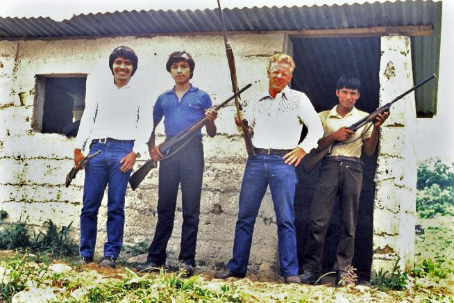
CHECK OUT THE WEBSITE TO GET A QUICK IDEA ABOUT WHAT TO EXPECT IN THE BOOK —with a whole bunch of movies I used to help understand–ABOUT MY MORE THAN HALF A CENTURY IN THE MOUNTAINS OF THE MAYA. There were some great times, but also sometimes scary moments, with narrow escapes from the Guerrillas, with shootouts on my plantation between the Army and the bad guysmy delivery van used afterwards to carry dead and wounded to Coban, and then interestingly once a narrow escape from the opposite side of the political spectrum–a Right-wing Death Squad that murdered 9 of the directors–including their entire families, of a cooperative I helped with in Comalapa among the Cakchiquel Indians! They considered cooperatives “communistic!” Then there was my fight with Gangbangers in Guatemala City, written about in COMBAT HANDGUNS magazine, etc., etc. for 50 years!

The MAYA book is downloadable FREE.

Click on this link to READ & SEE THE DETAILS OF THE MAYA STORY https://www.guatemalanfoundation.org/

IN THE APPENDIX OF THE BOOK, YOU CAN READ THE ENTIRE ARTICLE

IT’S IMPORTANT TO SET GOALS…EVEN IF IN THE END YOU ONLY ACHIEVE 50-75% OF THEM. WITHOUT A GOAL TO WORK TOWARDS, LIKE “GETTING TO THE GRANDADDIES,” I LIKELY WOULDN’T BE MOTIVATED TO WORK OUT EVERY DAY TO GET STRONGER, AND LIKELY NOT EVEN BOTHER DRIVING TO THE TRAILHEAD. WITH MY GOAL SET, FOLLOWED BY WORKING TO ACHIEVE IT, I WILL BE STRONGER & FOR SURE GET HALF-WAY…..OR MAYBE ALL THE WAY & GET NEW PHOTOS OF THE INSPIRING CUTTHROAT TROUT SPAWNING IN THE CREEKS THAT FEED GRANDADDY LAKE & MUCH MORE TO INSPIRE ME TO SET A NEW GOAL!

SEE YOU NEXT WEEK WHEN I’LL SHOW YOU GLIMPSES OF:

THE NATURALIST BASIN.

THE INSPIRING SIGHT AS YOU ENTER NATURALIST BASIN:

THE WATERFALL that empties the Morat Lakes in NATURALIST BASIN.

*********************************

UPDATE SUNDAY Feb. 13, 2022 – 16 months of STRUGGLE LEARNING TO WALK AGAIN in pictures — PLUS A NEW GOAL & MULTIPLYING the CHALLENGE with 2 NEW FREE EXERCISE SYSTEMS — MORE BEAUTY FROM THE UINTAS. BOOK: My Life in the Mountains of the Maya finished…finally!

THIS IS THE HISTORY OF MY HIGH UINTA PROJECT WITH 2,000+ MILES OF BACKPACKING/EXPLORING FROM 2003-2019 WHEN I PUBLISHED MY HIGH UINTA BOOK — FOLLOWED BY A WORN-OUT SPINE WITH 4 BACK SURGERIES FROM 2012-2020 & BEING UNABLE TO WALK OR STANDUP TO TAKE A SHOWER & LOSING THE MUSCLES IN MY LEGS–ESPECIALLY THE RIGHT ONE THAT WAS DEAD — THEN LEARNING TO WALK WITH A WALKER & PUSHING MYSELF AS EXPLAINED IN PAST POSTS — THEN WITH BABY STEPS LEARNING TO WALK AGAIN WITHOUT ANY DEVISE & LEARN TO FALL WITHOUT HURTING ME & LEARN TO GET UP BY MYSELF — THEN TO FINISH THE 2021 SEASON ACTUALLY DOING A 1 MILE HIKE IN THE UINTAS USING TREKKING POLES, BUT IT HURT ME SO THE CHALLENGE CONTINUED UNTIL NOW.

I’M SHARING MY EXPERIENCE AS IT COULD BE OF HELP TO SOME OF YOU THAT LIKELY WILL HAVE CHALLENGES ALONG YOUR PATH — QUITE A FEW HAVE ASKED ME TO SHARE MY EXPERIENCE…..BASICALLY OF…… “NEVER GIVING IN, NOR GIVING UP ……….EASILY!”

This winter my exercise devise has been the stairs below the American Fork Fitness Center, gradually doing more and more laps–up & down, until getting up to doing 32 laps with the goal of doing 40 a day by backpacking season.

THESE ARE THE STAIRS BELOW THE FITNESS CENTER WHERE DAILY I HAVE BEEN WORKING TO BUILD MUSCLE and ENDURANCE.

Doing 40 laps would be equal to the elevation gain from the Grandview Trailhead up to Hades Pass that we call “THE GATEWAY TO THE GRANDADDIES.” I’ll insert below a wonderful photograph of Grandaddy Lake, the largest in the High Uinta Mountains. There are 26 alpine lakes in the Grandaddy Basin.

BUT I HAVE REALIZED THAT TO PREPARE ME FOR HIGH UINTA TRAILS–LIKE SOME STRETCHES OF THE HADES PASS TRAIL YOU SEE BELOW, THEY HAVE STEPS THAT ARE MUCH HIGHER THAN THE ONES I’VE BEEN DOING SEEN ABOVE, SO I DO THOSE STAIRS TO WARM UP, AND THEN GO EACH DAY TO WHERE THE STEPS ARE AT LEAST 50% HIGHER….YOU’LL SEE AFTER “the rocky trail.”

SO, I’M BACK TO THE AMERICAN FORK AMPHITHEATER JUST WEST OF THE LDS TEMPLE, WHICH PREVIOUS TO ALL THE PRESENT PROBLEMS I USED TO HELP KEEP ME IN SHAPE DURING THE OFF SEASON. THE STEPS HAVE HAND RAILS WHICH I NEED AS MY BALANCE ALSO VANISHED ALONG WITH MY ABILITY TO WALK.

BELOW YOU SEE ME GOING UP & DOWN.
THE STEPS BELOW THE FITNESS CENTER WERE 7″. HERE THEY AVERAGE 11 INCHES THAT HAS MY RIGHT LEG–THAT FOR MONTHS WAS DEAD–FEEL AN OBVIOUS DIFFERENCE & NEED OF THIS UPGRADE IN HOPES OF BEING READY FOR THE UINTAS. I HAVE BEEN DOING DAILY 10 LAPS AT THE FITNESS CENTER, THEN 10 LAPS HERE–A “LAP” BEING UP & DOWN. I WILL GRADUALLY INCREASE THE LAPS. I ALSO DAILY DO SOME WALKING ON THE STREET USING THE WALKER, and ALTERNATE WALKING, THEN JOGGING, 20 to 30 YARDS EACH TIME–which has my legs feeling sore afterwards indicating that it is helping to build muscle and increase my strength & endurance.

AS I EXPLAINED IN THE PREVIOUS POST, THE ABOVE EXERCISES ARE DONE 5 DAYS A WEEK. FOR THE 6th DAY I GO EAST TO THE FOOT OF MT. TIMPANOGOS, AND USE THE GROVE CANYON TRAIL. AS SEEN BELOW–for last week–USING TREKKING POLES I HEADED UP THE TRAIL FOR ABOUT 30 MINUTES TO WHERE THE TRAIL LEAVES THE ROAD & WILL ADD ON ABOUT 100 YARDS/WEEK.

THIS WAS LAST WEEK Feb. 6th.
THIS WAS THIS WEEK. I GOT TO THE TRAIL and THEN HIKED FOR ABOUT 10-15 MINUTES MORE THAT I ESTIMATED WERE AT LEAST THE ADDITIONAL 100 YARDS FOR THIS WEEK & WILL KEEP ADDING ON AND LENGTHENING THE DISTANCE and HOPEFULLY BE ABLE TO DO SOME BACKPACKING IN THE UINTAS IN MY 87th YEAR.

EVERYTHING I’M DESCRIBING LIKELY SEEMS SORT OF “MICKEY MOUSE” FOR MOST OF YOU, BUT CONSIDERING THAT A YEAR AGO I COULDN’T EVEN WALK, & STILL HAVE THE DANGEROUS MISALIGNMENT OF MY SPINE WITH CONSTANT PAIN–but I think is gradually being reduced as I exercise more, I FEEL EXTREMELY BLESSED TO BE ABLE TO DO WHAT I’M DOING–and I CAN ADD THAT IT FEELS WONDERFUL TO HAVE AGAIN DEVELOPING MUSCLES THAT ACTUALLY FEEL THE SORENESS & STIFFNESS THAT COMES AFTER A HEAVY WORKOUT!

NEXT I WILL GRADUATE TO THE HIGHER STEP UPS–SEEN BELOW AT THE Amphitheater, but with NO HAND RAILS, so will use my trekking poles, and hope to get strong enough with good balance to not need the poles–and then be ready for the HIGH UINTAS!

NOW…….AGAIN WE GO INTO THE HIGH UINTA WILDERNESS from the CHRISTMAS MEADOWS/STILLWATER TRAILHEAD ON THE NORTH SLOPE.

LAST WEEK WE WENT UP STILLWATER FORK OF THE BEAR RIVER and SAW KERMSUH, RYDER & McPHEETERS LAKES. BACK DOWN THE TRAIL, BEFORE THE KERMSUH TRAIL, or 2.4 miles up from the Trailhead, WE COME TO A SIGN POINTING TO THE EAST WITH A TRAIL THAT CLIMBS UP ALONG OSTLER FORK OF THE BEAR RIVER, OUT OF THE CANYON LEADING US TO THE AMETHYST BASIN. My book gives all the distances, and information, including topographical maps of the beautiful area with Ostler Peak on our right. Along the way you can go off-trail to visit Salamander Lake, then continue up into the high country with large Amethyst Lake at the end of the trail, but along way are also off-trail Ostler Lake, as well as Toomset Lake. I’ll insert photos of Ostler Lake with my daughter Mahana fishing and Ostler Peak in the background, and then Amethyst Lake with it’s turquoise colored waters.

OSTLER LAKE REFLECTS OSTLER PEAK with my daughter Mahana doing some early morning fishing.

From the north end of Ostler Lake, if you go off-trail down along the edge of the mountain you come to TOOMSET LAKE, seen below. It is small, but full of colorful brook trout.

At the head of the Amethyst Basin is found quite large and beautiful–with its turquoise colored waters–AMETHYST LAKE.

AMETHYST LAKE with far in the distance what I call THE OSTLER SADDLE from which the next photograph of Amethyst Lake is taken .
AMETHYST LAKE from the OSTLER SADDLE. The color of its water varies depending on the time of the season, so you won’t always see the turquoise color. To get here I climbed up from the headwaters of the Rock Creek Drainage on the South Slope, going off-trail above Helen and Lightning Lakes.

Below we are still in the Rock Creek Drainage on the South Slope of the Uintas, looking north over Brinkley Lake at the southern side of Ostler Peak.

We are here viewing OSTLER PEAK’S south side, across Brinkley Lake, from the South Slope’s Rock Creek Drainage.

All of the information on what wonderful areas are accessible from the Christmas Meadows/Stillwater Trailhead, including topographical maps with distances inserted, and updated information on the fishing in each lake, and much more, is found in my book seen printed below–but available online. Once you have it on your computer you can put it on a thumb-drive and have your favorite printer make for you a copy as seen below. Scrolling down you will find information on the printer I use. Or you can print yourself the pages you will need for your backpack, and take the print-out with you to guide you in your adventure.

To get an online copy of this book, some have called THE ENCYCLOPEDIA OF THE UINTAS, send me $20 (don’t be afraid of sending a $20 bill as we aren’t south of the border) along with your email address, and I will immediately email you the link to download the book with my permission to share once with a friend. Send to: Cordell Andersen, 444 Elm St., American Fork, Utah 84003

*********************

MY SECOND BOOK THAT DETAILS MY 68 YEAR LOVE AFFAIR WITH THE MAYA — WITH OVER 1,000 COLOR PHOTOS

THE HISTORY HIGHLIGHTS A DILEMMA THAT ALL SEEKERS OF TRUTH SHOULD BE INTERESTED IN….CLARIFYIED with VOLTAIRE’S COMMENT……scroll down to the beginning of the last post to see what he said….

Click on this link to READ & SEE THE DETAILS OF THE MAYA STORY https://www.guatemalanfoundation.org/

****************************************

WILL BE UPDATED TOMORROW: Sunday, Feb. 13th. IN THE MEANTIME CHECK OUT THIS POST TO MAKE SURE YOU HAVEN’T MISSED SOMETHING……Scroll down to last post for info on dealing with Covid-19 & any variations. MAYA BOOK– quoting VOLTAIRE. Now… MY NEW CHALLENGE….GETTING READY FOR THE HIGH UINTA ’22 SEASON …INTO THE HILLS! EACH WEEK I’LL FOCUS ON info & photos of WILDERNESS AREAS: This week, the Eastern half accessible from Christmas Meadows/Stillwater Trailhead area….

MY PRINTED COPY OF THE FINISHED HISTORY AMONG THE MAYA

THE HISTORY HIGHLIGHTS A DILEMMA THAT ALL SEEKERS OF TRUTH SHOULD BE INTERESTED IN….CLARIFYIED with VOLTAIRE’S COMMENT (get the book and see for yourself the details):

“THOSE WHO CAN MAKE YOU BELIEVE ABSURDITIES, CAN GET YOU TO COMMIT ATROCITIES!”

Click to download: A FIFTY YEAR “IMPOSSIBLE DREAM” AMONG MY PEOPLE IN THE MOUNTAINS OF THE MAYA

***********************************

NOW TO THE HIGH UINTA WILDERNESS

CHRISTMAS MEADOWS & OSTLER PEAK and SPREAD EAGLE MOUNTAIN

This wonderful area is on the North Slope, accessed from the Mirror Lake Scenic Byway, north and down from Hayden Pass/entrance to the Highline Trailhead. All the information is found in my HIGH UINTA MOUNTAINS BOOK, pages 179-187. On my FACEBOOK PAGE I inserted pictures of Kermsuh and McPheeters Lakes–you can see going to: https://www.facebook.com/cordell.andersen . Below I’ll insert a beautiful picture of Ryder Lake mistakenly not included in my book as it is a breathtaking panorama. Climbing up from Ryder Lake to the right is above timberline McPheeters Lake, I’ll include below McPheeters, by the way it produces larger cutthroat trout than Ryder (which itself produces larger than normal trout).

RYDER LAKE IN MIDDLE BASIN OF THE STILLWATER FORK OF THE BEAR RIVER
McPHEETERS LAKE WITH MT. AGASSIZ on the left, and HAYDEN PEAK on the right.

In Middle Basin there are also several smaller lakes with fish, information in my UINTA BOOK, including topographical maps, and all the information you might need to have a great experience in West Basin, with Kermsuh Lake, and then in this Middle Basin–which I have to add, as I was reminded on FACEBOOK by my HIGH UINTA FRIEND, MIKE PACKARD, is accessible by real adventurers like him, by climbing that saddle to the right center from the Highline Trail area. Don’t attempt it unless you are a confirmed expert mountain climber!

HERE I AM IN 2017 ON ONE OF MY LAST BACKPACKS–INTO “THE GRANDADDIES” WITH TED PACKARD, MY ORIGINAL HIGH UINTA FRIEND WHO INTRODUCED ME TO THE UINTAS 70 YEARS AGO, & HIS SON MIKE WHO MADE THE ABOVE COMMENT.

To get an online copy of this book, some have called THE ENCYCLOPEDIA OF THE UINTAS, send me $20 (don’t be afraid of sending a $20 bill as we aren’t south of the border) along with your email address, and I will immediately email you the link to download the book with my permission to share once with a friend. Send to: Cordell Andersen, 444 Elm St., American Fork, Utah 84003

NOW A WORD OR TWO ABOUT MY PREPARATION TO MAKE ANOTHER COMBEBACK IN MY 87th YEAR IN 2022–Never promised to be easy!

I persist working on learning to walk with my baby steps, along with hiking, and climbing, 5 days a week with my NO COST EXERCISE UNIT seen below and one a week in the foothills using my previously hated trekking poles–as I can’t risk a fall that could kill me due to my misaligned spine.

I’m working on building muscles again in my legs, and developing again balance, I do the pushup thing daily, gradually increasing the repetitions, along with using my two 8 lb. barbells while watching TV–BYU ladies in a great comeback just beating Gonzaga— to build my upper body.

ONE OF THE CHALLENGES

THIS IS “THE GRANDADDY TRAIL” up from the Grandview Trailhead, above the bridge and is the first switchback up from the Wilderness Sign–TO MANUEVER THIS FOR ME–normally would be almost suicide.…so– WILL REQUIRE A NEW EXERCISE DEVISE & WORKOUT I WILL SHOW YOU IN THE NEXT POST on the weekend.

I can’t have much weight on my back anymore, so am working on extreme lightweight equipment changes, 5>>10 lbs. on my shoulders/back, and the rest in a couple of waist packs.

This is the 4.5 lb. survival pack I used last season for my historic 1 mile backpack last year to Fehr Lake. I will build on this base pack, adding enough to first do an over-nighter, then build on that.

All of that above must sound like a joke for all of you, but considering I couldn’t even walk for a time last year, and the life-threatening misalign ment of my spine–IT IS MONUMENTAL!……For my 2,000+ miles of backpacking/exploring in the Uintas to do my book, I did work on “lightweight backpacking” but I should have done better–like I’m now forced to do–and if I had of done so, I likely could have avoided wearing out my back/spine and still be doing long backpacks, rather than the “mickey mouse” ones I’m now preparing for!

AFTER 5 DAYS ON THE STAIRS……MY WEEKLY HIKE INTO THE MOUNTAINS

No vegetation sprouting, much less flowers, but rather a fascinating FOSSIL found along the trail. Always keep your eyes wide open for the wonderful VISIONS OF NATURE all around us. Doing so will make even a difficult hike, AN INSPIRING PLEASURE!

ONE OF THE WONDERMENTS OF THE LORD’S FASCINATING CREATION!

I got to where the trail leaves the road to begin switchbacking up the canyon. Each week I’ll add about 100 yards–which doesn’t sound like much, but by the time backpacking opens up in the Uintas, it will almost equal getting to Hades Pass “the Gateway to the Grandaddies!

I’LL KEEP YOU INFORMED…..IN THE MEANTIME GET MY BOOK & BEGIN PREPARING FOR A GREAT INSPIRATIONAL BACKPACKING/EXPLORING & FISHING/PHOTOGRAPHING SEASON!