Trip #14-2014-16 RED CASTLE AREA

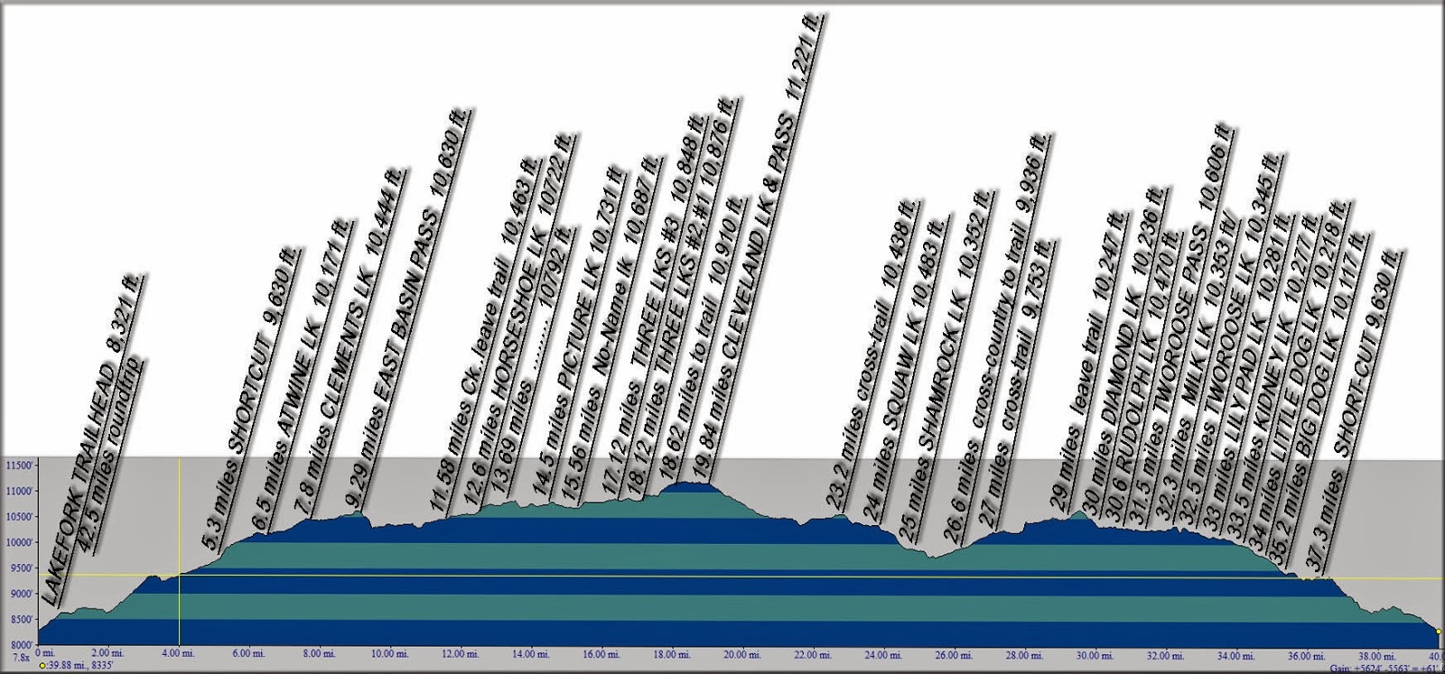
There are 4 maps in this post, and since we are going south from the trailhead, we begin with:
Map 1

 Map 1:  From the China Meadows Trailhead south up the trail past the first bridge.

 Map 2:  We conitinue up past where the North Slope Highline Trail crosses our trail and to Broadbent Meadows. and nearly to the 2nd bridge.

 Map 3:  This map takes us to the 2nd bridge, up the switch-backs into the high country, past the Bald Mt. trail, and then turn east on the trail to Smiths Fork Pass, and to East Red Castle Lake.

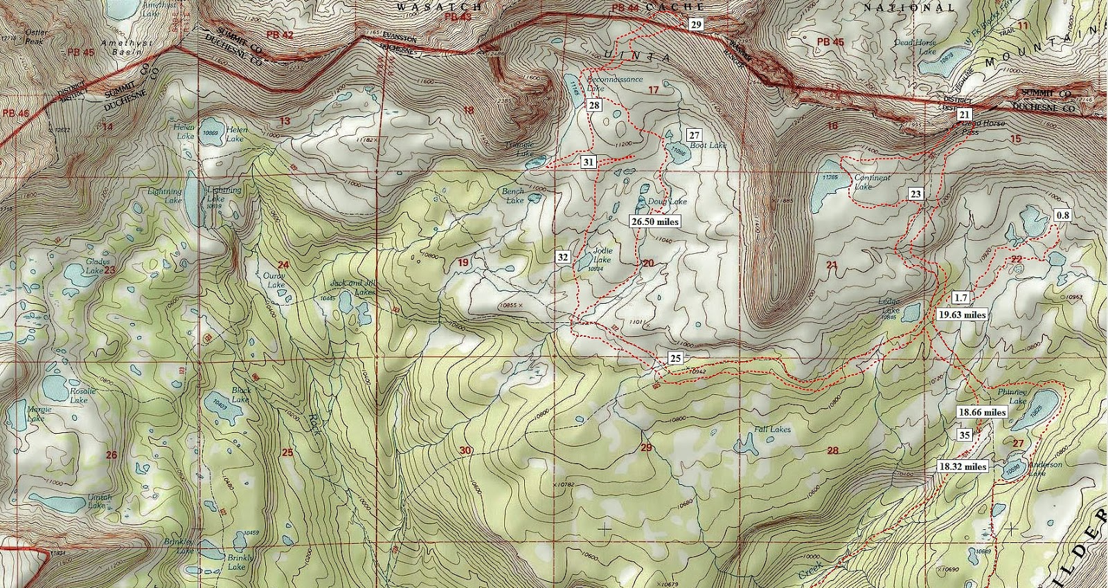
Map 4:  Here we begin at East Red Castle Lake, swing around Smith’s Fork Lake, then down around Red Castle, and up to Red Castle and Upper Red Castle Lakes.
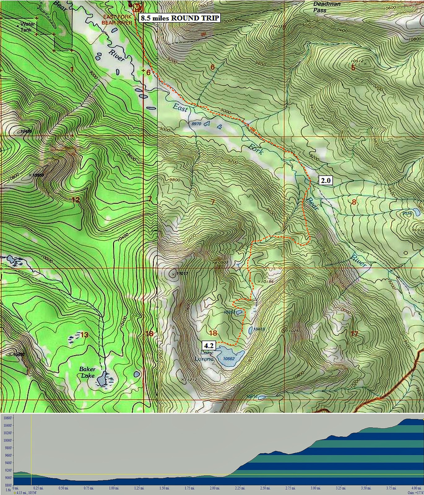

Trip #2-2014-15 EAST BASIN, CLEVELAND and TWOROOSE PASSES

Trip #2 – LAKE FORK TRAILHEAD – to East Basin Pass-Basin, Horshoe, Picture, X-83, Three Lakes, Cleveland Pass-Lake, Squaw Basin-Squaw, Shamrock, Diamond, Mid, Rudolph, Tworoose Pass, Lake, Lily, Kidney, Little Dog, Big Dog, back to Trailhead.  16 lakes, 43 miles, 5-7 days.  

This topographical map shows most of the Lake Fork & Rock Creek drainage’s up to the crest of the High Uintas.  The portion involving this backpack is the right-lower section.  This is on the South Slope of the Widlerness whose boujdary is seen in red crossing the map.  The elevation profile is below showing at each trip mile marker the elevation.
SCROLL DOWN TO SEE ENLARGED AREA OF BACKPACK

Trip #3-2014-25 ROCK CREEK DRAINAGE

rip #3  ROCK CREEK TRAILHEAD – Rock Lakes, Young, Anderson, Phinney, Ledge, Continent Lakes, Dead Horse Pass, Doug, Boot  and Rconnaissance Lakes, Allsop saddle, back to Trailhead.    10 lakes, 50 miles, 6-8 days  Sorry the topo map I had here wasn’t too good, so here we have it divided into 4 maps.  The first below is #4, so scroll down to #1 and scroll up following the trail up.

Map 4 – 


Map 3 – Young Lake

Map 2- up towards Squaw Basin

Map 1 – Stillwater Trailhead- up to first cross-trail


Trip #4-2014-15 FOX-QUEANT, and NORTH POLE PASSES

Trip #4 – WEST FORK WHITEROCKS TRAILHEAD – Queant, Cleveland Lakes, Fox/Queant Pass, Crescent, Fox, Brook Lakes, North Pole Pass, Taylor Lakes.  7 lakes, 21 miles, 4 days,  Topo Map and elevation profile.

The Whiterocks Drainage is on the southeast side of the  Uinta Mountain Range and is out of the Wilderness area.  This backpack leads to the Fox-Queant Pass which is on the boundary of the Wilderness Area.  From there we swing through the upper reaches of the Uinta River drainage, then up to North Pole Pass which is just outside of the Wilderness, but is so close I have included it in the Wilderness Area’s 22 passes.  These are two of the remaining ones I haven’t scaled.