

SCROLL DOWN FOR BUCKLEY MT. EXPLORATION
PREVIOUS POSTS:
PREVIOUS POSTS:
*THE ASSAULT ON “LITTLE ANDY LAKE”
*PIONEER TIMBER SLIDES: Slide Canyon to top of Slide Mountain
************************************
CHECK OUT THE SPECIAL FACEBOOK PAGE:
Cordell Andersen Photography, and the STORE,
where many of my photographs from the High Uintas are available. If you don’t see in the STORE what interests you, but find it in the
Photography, or in one of my trip reports, let me know and I’ll advise the site manager to get it there.
where many of my photographs from the High Uintas are available. If you don’t see in the STORE what interests you, but find it in the
Photography, or in one of my trip reports, let me know and I’ll advise the site manager to get it there.
****************************************
UPDATE September 29, 2016:
Since my last heavy duty backpack in the High Uintas, I revealed my SECRET SIX SUPPLEMENTS, that I have done my best to show how they effectively help me meet my goal of (sort of tongue in cheek….but SERIOUS BUSINESS!):
“BEING 80+, LOOKING LIKE 60, BEHAVING LIKE 30, & WEIGHING LIKE WHEN 20!”
Note: They are listed towards the end of the
“Assault on Little Andy Lake” backpack photo/essay.
Doing this has boosted me to a higher level I never thought possible for an old guy! I hope & pray that a few can be blessed by all of this, just as I have been.
Hope to meet you on the trail…..
Cordell M Andersen
FOR DETAILS GO TO ARTICLE ON MY WEBSITE and GEAR/SUPPLEMENTS
*********************************************************
September 20, 2016
EXPLORING TODAY THE BUCKLEY MOUNTAIN TIMBER SLIDE….
& FINISH WHAT I STARTED IN 2014 WHEN AFTER A MILE OR SO REALIZED I WAS SICK WITH “SHINGLES” & HAD TO RETREAT TO CIVILIZATION

THE FIRST TIMBER SLIDE AUTHORIZED
I quote information that comes from
‘
“The Utah County Court Minutes, from February through July 1853.”
“Early in 1853, Alfred Walton, Jerome Benson, and a Mr. Wilson received permission from the Utah County Court to build a timber slide down the canyon located between the two peaks rising south of Slate Canyon. This slide would be located conveniently between Provo and Springville. In order for the grant to be valid the company had to build the slide during the coming season. If the men constructed the slide, they could control it and have jurisdiction over the timber on the mountain above it..”
This permission was granted first, for the area known as Buckley Mountain that has two peaks, with a ravine separating the higher on the north from the lower on the south–located between Provo & Springville, Utah. So via Google Earth from the Y Mt./Slide Canyon/Mt. area east of Provo, we fly south to Buckley Mountain.


Driving south along the Wasatch Front in Utah, you get on the old highway between Provo and Springville, Utah, driving along the two Buckley Mountain peaks where the first timber slide was constructed.

The yellow arrows point at the slide pathway which can be seen in the following views during different seasons of the year.

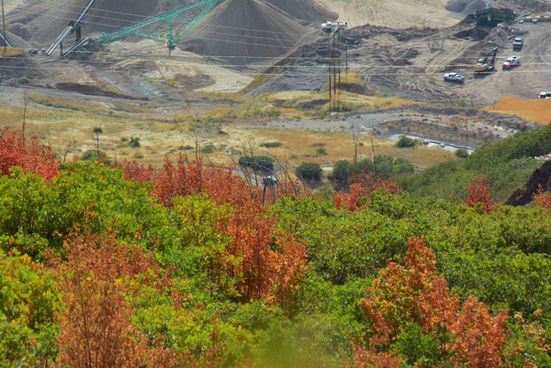
Here seeing the lower end near where the lumber products were loaded into wagons in the area seen below from Google Earth
the pathway right here V

Most of the roadways and excavations seen in this view are from more modern times. The “V” in the above caption points to the pioneer slide pathway that angles across the picture and ends in a sort of triangle shaped area.

The slide pathway is very visible from the highway, going up the right side of the draw, seen above in late Fall & early Winter.
Below, we see it in two photographs in early Fall. This is not a hiking trail as I assumed for many years, rather the pathway of the timber slide created in 1853….163 years ago.
Below, we see it in two photographs in early Fall. This is not a hiking trail as I assumed for many years, rather the pathway of the timber slide created in 1853….163 years ago.
It appears that the slide pathway began at the rock outcrop in the left upper corner of the photograph below, or ends there as we go up.


Below follow Google Earth views showing a series of images from the bottom up to the rock outcrop.


The SPOT Tracking icon is where I got to in 2014 when I realized I was sick with shingles and had to turn back….fueled by PROTEIN PLUS!
The slide pathway ends in the shadows of the rock outcrop.
The slide pathway ends in the shadows of the rock outcrop.

September 20, 2016
WE BEGIN THE NEW EFFORT

Looking down from my parking place between Provo & Springville
AGAIN, BETTER PREPARED TO FOLLOW THE
TIMBER SLIDE PATHWAY

With elk skin gloves and long sleeved shirt to protect me from the heavy vegetation, which, as I have mentioned is worse than any jungle I’ve ever encountered in Guatemala.

From this spot, halfway up the foothills, taking me above the quarries along the highway, there is a game trail that takes me up to the beginning of the timber slide pathway.


In the above photo the pathway angles diagonally across the picture.
The valley is smokey due to several forest fires in the mountains up Spanish Fork Canyon.
The valley is smokey due to several forest fires in the mountains up Spanish Fork Canyon.

All of a sudden the sound of helicopters passing overhead has me looking up and seeing three of them heading for the fires.
Those who know me, realize that you will be blessed by me sharing a few of my
VISIONS OF NATURE along the way.

There are many of such VISIONS !


I”m now up the first steep climb….and climbing up always, here through a grassy area where on the ground the pathway is quite noticeable, but not visible in the picture.
Looking back to keep us in touch with where we are.
Looking back to keep us in touch with where we are.


Again into the very visible pathway going up through the scrub oak & maple jungle….
……and from the same spot looking down.
……and from the same spot looking down.

As I struggled up….and it was a lot steeper than these picture show, I began realizing that just two days rest since my difficult ascent up the Slide Canyon Timber slide, maybe wasn’t enough, and I began thinking of perhaps turning back….but short rest stops had me pressing on.


It was at about this spot that I ran out of food and water as I had in my mind that this was to be a quick, short hike. But it was turning into a bit more than that for an old 80 year old and I decided I’d best turn back.
But, again, after a bit of rest decided to just go a little further to get a better view of where I was.
But, again, after a bit of rest decided to just go a little further to get a better view of where I was.

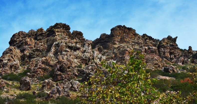
All the unique rock formations are on the north side of the ravine.
That “little further” had come into view the rock outcroppings where I knew the slide pathway started, or ended.

So I pressed on to reach my goal.


All of a sudden I reached the area where on Google Earth views I could see small cleared spaces in the area where timber products were brought from up higher, and loaded into the slide, “trough” or “chute.”

It was in this area where I hoped to find artifacts, even though by now I was coming to understand that, over 160 years of time most wood remnants would have likely rotted away.
We weren’t dealing here with the kind of tropical wood we had in Guatemala that literally lasted for even thousands of years in Mayan ruins–and which wood we used in areas like Chulac, mentioned in my previous post, to make outhouse floors that wouldn’t rot.
We weren’t dealing here with the kind of tropical wood we had in Guatemala that literally lasted for even thousands of years in Mayan ruins–and which wood we used in areas like Chulac, mentioned in my previous post, to make outhouse floors that wouldn’t rot.

I fought my way through the scrub oak and maple to find the cleared spaces, looking for artifacts.

And, finally found ONE! You see it below, a very rusty artifact.
I did, as I have tried to do with tie hacker artifacts, leaving them in place for scientific examination. In this case it’s not likely that any archaeologist will ever go up that mountain, and so I should have brought it home to preserve and examine carefully….and maybe will go get it one of these days.

Did tin cans exist in the time of the timber slides?
THE HISTORY OF TIN CANS
It began in France in 1795 when Napoleon Bonaparte offered a reward for someone inventing a method of preserving food for his military forces. Finally, in 1809, Nicolas Appert won the reward developing the sterilization method of preserving foods, but using glass bottles. A year later in England, Peter Durand patented the tin can for preserving food. By 1847-49 machines were patented in the U.S. for making tin cans speeding up the process from 5-6/hour to 50-60/hour, and preserved foods grew in popularity. By 1866 an improved method of sealing the cans was patented.
So in the time of the Pioneer Timber Slides, tin cans existed. Whether my find was from then, who knows…..but, since the slides, nothing else much has happened in that area to have a rusty tin can be there.
IN THE MEANTIME….ONE CONCLUSION:
Those who worked up on Buckley Mountain were pretty good at abiding by LAW #1:
“LEAVE NO TRACE!”
Below are views of VISIONS OF NATURE taken from the rock outcropping where the timber slide pathway ended……

Looking to the north

Looking to the south

Swinging down a little to the southwest

Looking down where I had come from….and now had to head down……
…….and zooming in on my car that I had to get to for food and water!
…….and zooming in on my car that I had to get to for food and water!
Down I go, looking back to the northeast, and showing below a 2014 exploration picture at one of the previously shown rock outcroppings.


Below is shown the Google Earth SPOT TRACKER view of the exploration, with #6 slightly mistaken showing I was on the north side of the ravine–which never happened.


Last of all we are seeing a view of the lower end of the slide pathway that curves across the picture where the lumber products were loaded into wagons and hauled to build Springville.

Last of all I quote again the ending from the previous post:
“Large logs as well as small ans [ones] would run with great rapidity….We would often start timbers at the top end of the slide an[d] it would run the entire [way to the] loading place with out a stop.”
Then quoting the journal of a John C. Dowdle, who wrote: [It worked] “admirably as far as tried.” John and his brother Robert, worked on the construction of the slide, harvested logs to be used as fuel and lumber, and slide them down the chute. Since lumbermen used the slide mainly in the winter, they labored under unfavorable working conditions. Dowdle said at times the snow was from two to eight feet deep on the mountain. Alexander P. Chesley, who helped cut and slide the timber, lived in such destitution that he had to wrap his feet in burlap sacking in place of shoes. Working in these dire circumstances presented at least one advantage. Dowdle wrote, ‘By laboring in this manner during the winter we made a tolarable good living.'” p.133
My admiration for the pioneers grew exponentially once more, and I am filled with gratitude for the work and sacrifices they made to help make possible so many blessings we now enjoy–and we in turn should in our own way focus some of our energies also on making the world a better place for others.
NOTE: The historical references I have quoted are pretty much all that exists so far, mostly coming from D. Robert Carter’s two books pictured below.


The last SPOT TRACKING line from the Buckley Mountain timber slide
HEADED DIRECTLY FOR WHAT I NEEDED MOST:
McDONALDS
near the Provo City Mall.
*********************************************************
HEADED DIRECTLY FOR WHAT I NEEDED MOST:
McDONALDS
near the Provo City Mall.
*********************************************************