The NEW OBSTACLE I mention in Part 2 has me putting on hold Part 3. Give me a week or so. UPDATE: April 20, 2012 Scroll down to see what the specialists concluded and the treatment that will have me overcoming the “obstacle” and backpacking still in my 77th year. May 16th UPDATE: “overcoming the obstacle” got a bit more complicated, so it looks like the“backpacking still” will mostly be this old guy doing it in my 78th year! “I’m going under the knife” as there is too much of me still working pretty good TO GIVE IN! May 17th UPDATE: On May 24th I will undergo surgery for my “degenerative lumbar spinal stenosis.” That translated to High Uinta geezer English is: “I’m a worn out old guy!” Recovery can take as long as 12 months, but knowing me, the Dr. thinks I might be ready to backpack by August 24th. I’ll apparently be in the hospital at least 3 days, then a week or so of bed rest at home, and then gradually get back in shape and hope to at least do what I have listed as my first trip for this summer. I will do my darndest and see how it goes. While I recuperate and recover I’ll be doing all the research I need to put all this together, but before the surgery I’ll do PART 3: GEARso that it might be in time to help all of you with a suggestion or two.. and then I’llkeep you updated on things like the Mirror Lake Scenic Byway opening, and do some YouTube videos and photo/essays on a few of the fascinating historical aspects of the Uintas you probably don’t know about, etc.
May 17th UPDATE: On May 24th I will undergo surgery.…
I will appreciate the prayers of all my High Uinta Friends and my large “congregation of REAMS customers, employees and friends.”
BACK SURGERY June 9th UPDATE: “Transforaminal Lumbar Interbody Fusion L4-L5” was done on May 24th. I returned home on the 26th with instructions to not bend over, twist, or lift anything. By my first post-surgery visit on June 5th I was afraid I had exercised too much and maybe done some damage, but the x-rays showed all was fine. I’ll insert an x-ray below showing the titanium thing-a-ma-jiggs installed in my spine to keep things straight until bone grows up to make me strong again.
In spite of the pain, etc. Dr. Richie still believes I will be able to backpack by late August. I have good days, and bad days, one of my daily walks being to REAMS “where everybody knows my name.” It’s my CHEERS! Yesterday, a painful day with difficulty sleeping, had me finally at midnight seeing a DVD my son David gave me–“127 DAYS,” WOW! Aaron Ralston did everything wrong to get himself into his impossible situation–but what he did to survive will stop me forever from whining about a little pain.
SURGERY COMPLICATIONS July 18th Update I was doing fine with my recovery for about 2-3 weeks when I had increased my daily walking, twice a day, to a total of as much as 6 miles. But then left leg pain and weakness took over and the Dr. suspected that my persistence at continuing to work with pain for 3-4 months possibly caused nerve damage. He told me to back off on the exercise and re-evaluate at my July 17th visit. I was in tough shape for that visit, and today as I report. I did go through a couple of weeks of hell to get off the narcotic pain killer and sleep aid prescribed by the Dr. and am struggling to get along with over the counter pain killers. The next step is for the Dr. to try and learn what the heck’s going on by having me undergo a “CT Myelogram L Spine” scan in a week after somehow going through 7 days without Excedrin, Ibuprofen or Noxaprene (pain killing blood thinners). Last night was the first with basically not being able to sleep. I will find a way to get through it, and do my darndest to finish what I started and avoid being “JUST A BUNCH OF HOT AIR! I always have in mind:
CT Myelogram scan results….July 27th
My doctor and the radiologist concluded from the scan that everything is normal and that I should experience a full recovery. I just have to be patient and very careful with walking and exercise as apparently there was nerve damage and being an old guy now has recovery happen in slow motion! That for sure will have me waiting until August 2013 to accomplish the four trips planned for this summer and give me enough time to learn to walk all over again and have sufficient strength to get the job done. I’ll insert two print outs below from the scan the doctor gave me.
Trip #1 – LAKE FORK TRAILHEAD – to Upper Brown Duck Basin – Short-cut to Atwine, Clements, Stewart, X-78, Twin, Mud, Aspen, Island and Brown Duck Lakes – back to Trailhead. 10 lakes including some no-name lakes, 25 miles, 3-4 days.
This area is located on the High Uinta’s South Slope north of Duschesne, Utah. This 25 mile backpack’s elevation profile is below with elevations noted at each trip mile marker. The red jagged line going across the map is the High Uintas Wilderness boundary–the wilderness to the north.
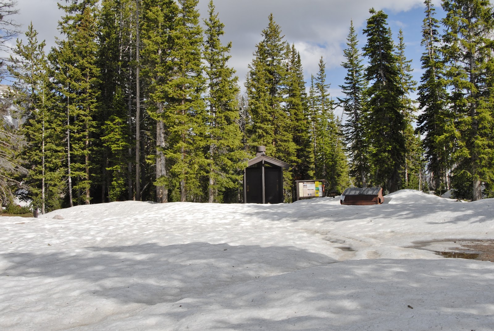
MIRROR LAKE SCENIC BYWAY and WOLF CREEK PASSES OPENclick for info This is the earliest opening in my experience The NEW OBSTACLE I mention in Part 2 has me putting on hold Part 3. Give me a week or so. UPDATE: April 20, 2012 Scroll down to see what the specialists concluded and the treatment that will have me overcoming the “obstacle” and backpacking still in my 77th year. May 16th UPDATE: “overcoming the obstacle” got a bit more complicated, so it looks like the “backpacking still” will mostly be this old guy doing it in my 78th year! “I’m going under the knife” as there is too much of me still working pretty good TO GIVE IN! May 17th UPDATE: On May 24th I will undergo surgery for my “degenerative lumbar spinal stenosis.” That translated to High Uinta geezer English is: “I’m a worn out old guy!” Recovery can take as long as 12 months, but knowing me, the Dr. thinks I might be ready to backpack by August 24th. I’ll apparently be in the hospital at least 3 days, then a week or so of bed rest at home, and then gradually get back in shape and hope to at least do what I have listed as my first trip for this summer. I will do my darndest and see how it goes. While I recuperate and recover I’ll be doing all the research I need to put all this together, but before the surgery I’ll do PART 3: GEARso that it might be in time to help all of you with a suggestion or two.. and then I’llkeep you updated on things like the Mirror Lake Scenic Byway opening, and do some YouTube videos and photo/essays on a few of the fascinating historical aspects of the Uintas you probably don’t know about, etc. In the meantime entertain yourself and be overwhelmed seeing the Lord’s beautiful creations–with my two updated complete collections of wildflowers and flora, many you’ve never seen before, divided into two parts: (no sound, so put on some great music and enjoy) YouTubevideo #10–WILDFLOWERS OF THE FOOTHILLS (117 varieties) YouTubevideo #11–ALPINE WILDFLOWERS and FAUNA OF THE HIGH UINTAS (204 varieties) Eventually they will all be presented in a photo gallery identified with common and scientific names and other information. YouTubeVideo #9-Part 1: BACKPACKING 2012–SCHEDULE and PREPARE or HAVE ONE TOUGH TIME Photo/Essay: #9-Part 1: BACKPACKING 2012–SCHEDULE and PREPARE OR ELSE…….! YouTube Video #9-Part 2: Overcoming Obstacles with Nutrition/Supplements Photo/Essay: with links to all the imporant stuff #9-Part 2: Overcoming Obstacles with Nutrition/Supplements
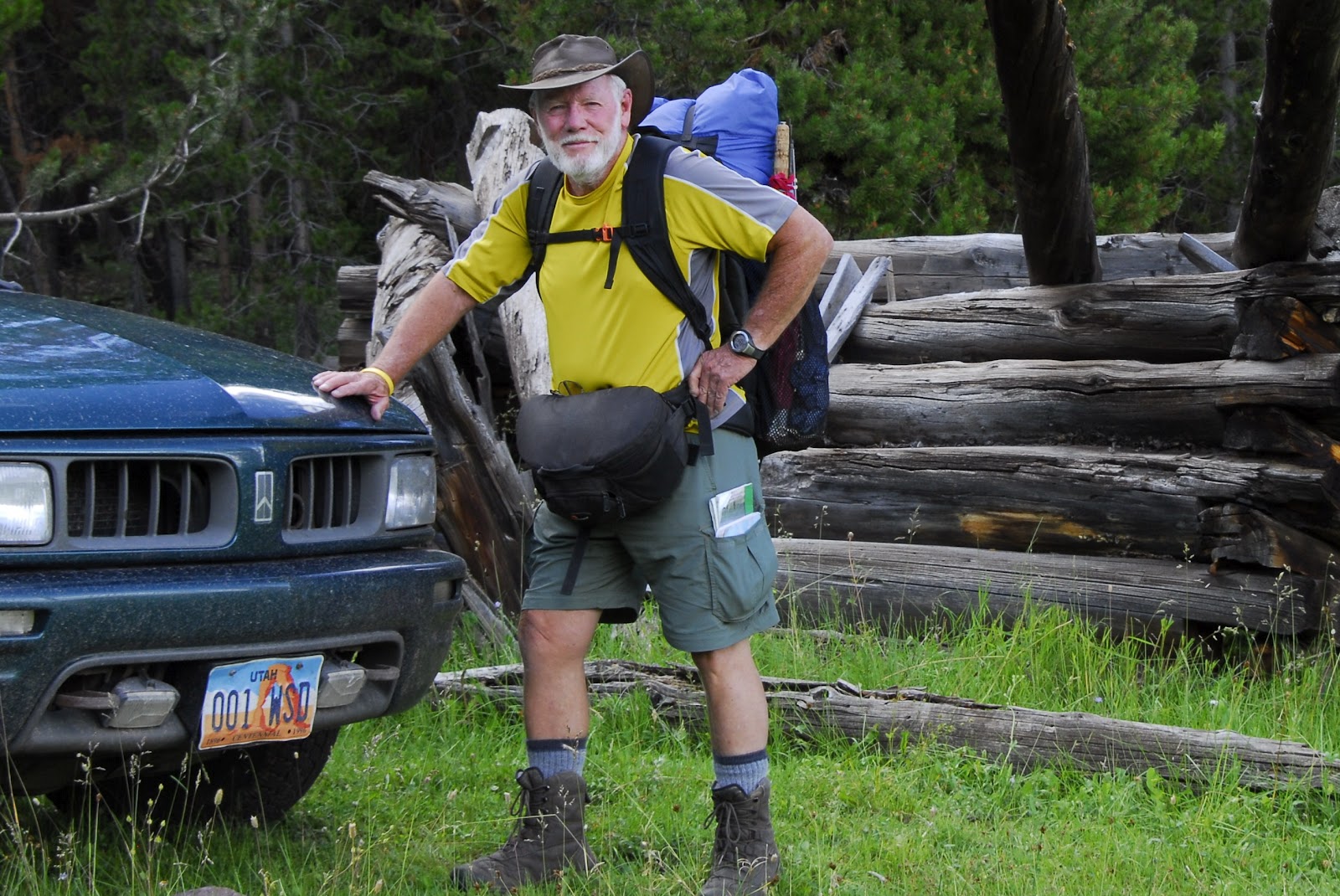
Here I am again to give you a few tips about how you can have a great backpack or two this summer.. NOTE: Down near the end of this post I talk about a new obstacle to me accomplishing my goals. One possible solution is discussed. This is an incredible discovery, so check it out carefully when you get to it.
Remember in Part 1 we talked about heavy duty work getting in great physical shape….or else…..or have one tough time that just could be a nightmare if you’re not willing to put in the effort to be strong.
In this segment, Part 2, I will focus on overcoming obstacles with nutrition and supplements—that one mature friend has called “the Holy Grail” for us older guys. As you will notice it also took a couple of surgical reconstructions. Of course there is also a YouTube video. It is a bit long but 17 minutes is a good investment that could mean enjoyment, or misery–or life and death. So take the time and get prepared.
In my case it all began in 1953 when I was on a suicide mission at Provo High School to become the smallest player in the history of the NFL, but in a vicious game against West High school I got wiped out and for 50 years limped with my “football ankle.”
Then at 45 I was becoming a cripple with arthritis from the “football ankle” up my right side to my shoulder and arm. I was getting desperate, but then one night heard a radio interview with Dale Alexander. Pay attention, this is critical for many.
He saved himself, his 80 year old mother and others from being cripples. His treatment was so effective he became known as the“Cod Father” His Cod Liver Oil. He discovered that taking 2 tbls. of COD LIVER OIL30 minutes before eating in the morning, and 30 minutes before dinner and keeping it up for 6 months has yourarthritis GO AWAY. It worked miraculously for me. Then for maintenance you take a tablespoon full (4 gel caps) once a day in the morning—FOREVER
Two years after the initial miracle I quit for a month and the arthritis all came back. I then started it again, and at 4 months the pain left me and has never returned, except when doing extreme exercise, but increasing the dose solves that problem. I must add that my body stiffness felt when I get up in the morning very literally is felt dissipating in about 10 minutes after taking my cod liver oil.
At the same time I was successful at losing 30 lbs., no small matter to say the least.Part of that was jogging and eventually running half-marathons, but that brought back pain in the ankle and metatarsilitis in the balls of my feet, and a rheumatologist told me to stop running, and forget backpacking.
I added Glucosamine/Chondroitin/MSMto my cod liver oil, and mademodifications to my running shoes and hiking boots, with an incredible combination of inserts.
I did 14 consecutive International Half-Marathons between my 58th and 72nd years
By then I was in the middle of my High Uintas Project and by 2006 the football ankle wore out and my ankle was reconstructed with 3 screws and a tendon transplant.
Of course I kept working out even with the cast on my leg and ankle, and kept backpackingusing a lightweight boot that gave my ankle support, but gradually moved to a lightweight low cut boot, and now just a mountain running shoe with one additional insert.
Along that 30 year trail I also had to begin coping with my “motor cycle knee,”also on my right side, after an accident, and a knee operation followed by the doctor’s advice to forget jogging and backpacking. Of course the cod liver oil, and Glucosamine/chondroitin/MSM helped me ignore his orders and keep going using a knee brace, but a year after the ankle surgery in 2007, my knee wore out and it was either become a couch potato, or back to surgery for a complete knee replacement.
So I got a titanium knee, did some intensive therapy—all of whichwas quite painful, and as you can see it looks horrible, but the important thing is that it works and I’ve kept on backpacking
For many years of normal living I only took 2 gelcaps/day of cod liver oil for maintenance and it was enough. But, now I take 6 in the morning as I’m dealing with major joint and arthritic problems while doing 7-8 miles, 3-5 times a week in my work. I take 2 more with my noon meal, and 1 prior to going to bed.I also persist at taking 2 capsules of Glucosamine/Chondroitin/MSM in the morning, and 2 at mid-day, and in addition also need 2-3 Excedrin, or better its Walmart equivalent that is much cheaper, and when in the midst of a heavy day repeat it at mid-day.With that I now head into the high country with no knee brace, and my lightweight, but great quality mountain running shoes.
NOW ON TO SPECIAL NUTRITION
Here I’ll only mention what I begin with every day—it is DEE’S CEREAL, . You can hit the pause and read the benefits of this great cereal. I will only mention that its claim to be “Heart Healthy” is no joke as I have also in the last 10 years or so had to deal with a couple of heart conditions. Several related emergencies I survived and describe in two of my Survival stories on the website. You will notice I mix in cinnamon as studies have shown it helps control blood pressure. I mix it with dhyrated milk, and sugar and put it to soak overnight so it needs no cooking. You can hit the pause button and see what else is said about this cereal which in Utah can be found in the cooler section at your supermarket.
Now to the nutrition supplements I use and why. All of them together add up to my MULTI-VITAMIN/MINERAL and MORE.
First isWELLNESS FORMULA.A powerful herb combination, and antioxidants known to provide energy, protection from stress, and support for the immune system. Normally I take 1-2 twice a day, depending on how tough the day is. If you begin feeling imbalances in your well-being (like coming down with a cold, flu, etc.) you should take 3-6 capsules of the WELLNESS FORMULA every 3 hours. So you should have an extra bag of these for emergencies
First isWELLNESS FORMULA.A powerful herb combination, and antioxidants known to provide energy, protection from stress, and support for the immune system. Normally I take 1-2 twice a day, depending on how tough the day is. If you begin feeling imbalances in your well-being (like coming down with a cold, flu, etc.) you should take 3-6 capsules of the WELLNESS FORMULA every 3 hours. So you should have an extra bag of these for emergencies
Next is STRESSCAREAnother herbal multivitamin/mineral/antioxidant and immune system support specifically when under physical stress such as backpacking. When working or backpacking I take 2 twice a day.
Then comes CHORELLA a super food considered the secret of longevity among some of the oldest people on earth. Click on it to learn more.
CoQ10 It is a vitamin-like compound essential component of cells and is necessary for mitochondrial energy production. Years of research has shown that CoQ10 supports healthy cardiovascular and immune system functions in addition to its vital role in energy production. I take one in the morning and another mid-day when backpacking.
VITAMIN D3is another crucial nutrient, especially for older individuals where natural levels of nutrients are lower than they should be. It is necessary for bone health, immune wellness and plays a crucial regulatory role for many bodily processes.
DHEAThis is the“Mother hormone”for both men and women as it converts into whatever hormone the body needs and is essential to keep your body in proper balance. Some have called it “the fountain of youth,”levels of which are known to fall precipitously with age, and with low levels common among those who suffer from cancer, heart disease, diabetes, osteoporosis and chronic fatigue. I take just one 100 mg capsule to begin the day.
SUPER B-COMPLEX with vitamin C and Folic Acid – B-vitamins help convert food into energy—obviously crucial for a backpackers and others involved in intense physical activity. I take one each morning
NOW TO MORE ATHLETIC SUPPLEMENTS
Above you see me in 2003 leaving on my 27 day “expedition” with 81 pounds on my back and around my waist. A mile down the trail I added 2 lbs. of water (1 quart). This was a monumental effort similar to doing a a half-marathon a day, and sometimes a marathon for 27 days and 236 miles. This required special conditioning and athletic nutrition without which it would have been a nightmare. I trained for it for years on my farm in Guatemala doing 4 miles of rolling hills 2-3 times a week with a 100 lb. bag of fertilizer on my back. If you’re not willing to train big time, don’t attempt it!
As you might have noticed I approach backpacking (and the work I do at Reams) as I did running a half-marathon.It could be argued that carrying a 30-50 lb. pack at elevations over 10,000 ft.for 5-6 milesis actually more difficult than running a 13 mile half marathon.So you should approach it, and its recovery each day similarly. Below are a few glimpses of the challenge.
Freshman orientation from Earlham College, Indiana on their 19 day backpack trip in the Uintas.
The Scott’s on the trail to Middle Basin up the trail from Christmas Meadows .
Mahana climbing East Grandaddy Mountain for the view of a lifetime.
Bushed after a backpacking day equivalent to running a marathon!
You need marathoner’s supplements to do it right and enjoy it.
ENDUROX-EXCELbuilds endurance, increases fat metabolism, and helps maintain healthy immune function. One investigation showed it to increase a marathoner’s performance by around 15%. I find myself clearly more alert and energetic taking 2 tablets each morning just before going to work, or beginning my hike for the day..
CALCIUM-MAGNESIUM A few years ago RUNNER’S WORLD reported a study showing that the mineral marathon runners lose most is calcium. The same for backpackers. Thus, 5 gm. ( teaspoon full) is added to the energy drink I mix in the morning and drink at about noon. Again in the afternoon 5 mg is mixed with my recovery drink (Endurox R4) after work or backpacking is finished. Then again at night mixed with HGH stimulant before going to sleep. This is also available in capsules.
ENDUROX R4 –this is a carbohydrate Protein formula usually used for recovery and “coming back stronger.” I mix it in the morning (on the trail only the powder with no water in my mixer bottle) to add water half-way through my day at lunch time to begin the recovery process for the remainder of the day, and another one on finishing hiking for the day for recovery. . To the Endurox I add Calciumn/Magnesium as explained above, and also extra Glutamine as mentioned below.
GLUTAMINE powder, capsulesis an essential amino acid with an important role in muscle development. Under extreme exercise, especially for older individuals, levels are depleted and need to be replenished to avoid muscle breakdown. RUNNERS WORLD reported that marathon runners who took 5 gms. of Glutamine after a race were able to avoid getting sick. I have certainly found this so in my own experience—thus these ingredients are added to my energy and recovery drink (Endurox R4 already has enough Glutamine for average people–I add 1 tsp for being an old guy with special needs). You can also get this in capsule form to avoid having to mix with a liquid.
SPORTLEGS is designed to support your body’s lactate energy system to help minimize muscle soreness. When backpacking I take three to begin the day and two on finishing the day’s hike to help recover and eliminate muscle soreness.
NO VITAMIN/SUPPLEMENT BOTTLES – of course I don’t take backpacking all these bottles and containers I’ve been showing you, but have a bunch of labled Ziploc bags for each take, plus a few extra of certain key supplements for when I might need to increase the dose, such as with WELLNESS and COD LIVER OIL.
As shown here I take a few wide mouthed plastic mixer bottles, actually free left over from your chocolate drink snack, etc. Just remove the labels and you’re ready to go. They weigh nothing, so you can take a few extras in case you need them.
To the left is my Dee’s Cereal mixed in the evening for the next morning’s breakfast. Another staple is eggnog mixed with dehydrated eggs, milk power, cinnamon and sugar (I take the powder mixed in a ziploc bag, and then mix it in a bottle like to the right–which as pictured has the FRS drink in it rather than eggnog). I have a couple of eggnogs every day which is the most delicious menu item always.
During the day, on the trail, I have a pack of FRS chewsin my pocket. This is promoted by Lance Armstrong, and NFL’s Tim Tebow, and me.
It is a mix of essential vitamins, plus Quercetin which is a powerful all-natural antioxidant found in fruits and vegetables.Once in a while in my work I begin getting tired and grumpy towards the end of my shift—and sometimes outright sick..I quickly pop 2 FRS chews in my mouth and within 10-15 minutes am able to cheerfully finish my day.On the trail I often have made the last few miles to my camping spot, or to the trailhead on the back of a couple of chews.FRS is also available in tubes of powder to mix with water as seen a couple of photos back.
EVENING and READY FOR THE SACK
RESVERATROL – this supplement contains the ingredient in red wine that is reported to be beneficial for one’s heart and longevity. One is taken along with the dinner meal.
CALCIUM-MAGNESIUMs taken 30 minutes before retiring.. This is a great aid to avoid Irritable Leg Syndrome, leg cramps, and aid to sleep better. It is taken along with HGH (Human Growth Hormone) stimulatormade up mostly of amino acids. Once again HGH becomes very deficient in elderly people that contributes to bringing on old age. .I will be experimenting with the tablet form pictured here, but usually use a powered form by Goldshield and pictured below.
IBUPROFIN – due to joint and leg pains as explained I take 2-3 ibuprofen at night to help me sleep better.
NOW FOR A NEW OBSTACLE
MY GOOD LEG! – around 35 years ago a small piece of shrapnel lodged in my leg above the knee. When the doctor worked on removing it he said I would maybe have trouble with that leg when getting older. I was horrified seeing him cut into my muscle cross-grain down to the bone to find it.. Sure enough a few years ago I began having hip pain on that side and gradually it has got worse encompassing the whole leg, sometimes weakening and almost collapsing. Sleep at night has become very difficult. Increasing the dose of cod liver oil to 3 at noon, 3 in the afternoon and 3 at night helped some, but not
My search for a solution had me discovering a product, D-Ribose, that sounded like it could help. I was willing to try anything so got a bottle.
“D-RIBOSE”is essential for synthesis and production and storing of energy for skeletal muscle and heart tissue, and aids in recovery and is a powerful antioxidant cleaning up free radicals that multiply with intense exercise. The dose was 5 capsules twice daily, which seemed like a lot so I went with 2. twice a day, but felt no change.
Then one day at work I had my leg almost collapsing every few steps and got real worried. At break I took 5 capsules and went back to work with the pain and weakening gone. It must not be arthritis or the cod liver would have solved it, so I’ll get it checked out soon, but in the meantime I’m sticking with D-Ribose, no matter what the cost. D-RIBOSE capsules–Powder For more information go to: END FATIGUE and HEART SMART CELLULAR ENERGY
Another one that caught my eye was CURCUMIN C3 COMPLEX – from the Tumeric root that “benefits joints and other tissues by helping to neutralize free radicals.” Alone it didn’t make much difference, but in combination with D-Ribose, it has me hustling around doing my 7-8 miles 4 times a week while unashamedly admitting that it is with a bit of a limp.
Within a few days I will have it checked out by the doctor and see what the heck is going on.
UPDATE: April 20, 2012 A few days ago I had Dr. Richard Jackson, who had done my knee replacement, check me out. His X-rays revealed the problem was with my lower back, two vertebra’s squeezed together and pinching the nerve causing pain down my leg. The next day they did an MRI on my back, it all boiling down to me having what they called: “degenerative lumbar spinal stenosis.” That translated to High Uinta geezer English is: “I’m a worn out old guy!” So apparently the shrapnel wound doesn’t have anything to do with it.
I’m down for a day or two, but far from out as this morning I was seen by Dr. Joseph Richey and given a shot of cortisone at the tail end of my spine that will have me by Monday hustling around Reams Supermarket and preparing for my High Uintas Project with Friday-Sunday off each week from now until August to do research in all the areas surrounding the Uintas, and then in August peck away at the 4 adventurous trips outlined in Part 1 of this series on Backpacking. However I will persist usingD-Reboseas it sounds like a perfect addition to keep this old geezer from “giving in” and plow forward until the job is done.
FREE NUTRITION and MEDICINE
NOTE: This was not included in the YouTube video.
I can’t really end this without another word about nutrition–the kind that will cost you nothing, but give big results. THIS IS NOT TONGUE-IN-CHEEK! Their incredible nutritive qualities are going to help keep me above ground and hustling.
that I have called the “Spinach of the Weed World.” Others have called them“The Gourmet Weed.”Of course you have them all around your home, at the park, and also in the High Uintas Wilderness, at all but the extreme elevations. They come and go but if they are around where you’re hiking or camping, think seriously about them. The leaves and the flowers can be used to increase the nutrition of your soup, or whatever. They can also be eaten raw as a salad. They have amazing nutritional qualities as the links in my photo/essay will demonstrate.
Here you see me adding dandelions to a pot of macaroni soup. THEY HAVE AMAZING NUTRITIONAL and MEDICINAL VALUE. ranked in the top 4 of all green vegetables, and the 3rd food in vitamin A content, only topped by cod liver oil and beef liver. The flower and leaves are high in the Vitamin B’s, and effective for dealing with stress. Also rich in potassium, iron and calcium, with medicinal benefits to cure high blood pressure, hepatitis, etc. and rich in enzymes to aid digestion. Of ALL VEGETABLES dandelions rank 9th best. I eat a handful daily, some in a salad, and more just slightly cooked along with swiss chard. For incredible information go to my website.
PURSLANEwhich you have among your flowers, and all over your vegetable garden. You likely even HATE IT! Below you see this old enemy–soon to become a cherished friend, and a shot with some cleaned and ready for my salad. This will help you be healthier down in civilization as it is not found in the High Uintas.
Purslane has 6 times more vitamin E than spinach, 7 times more beta-carotene than carrots, and is rich in vitamin C, glutathione, riboflavin, potassium, magnesium, phosphorus, tryptophan, and has more omega-3 fatty acids than any other leafy plant. It is also rich in protein. Purslane may have positive effects on the brain and may aid in such conditions as depression, bipolar disorder, Alzheimer’s disease, autism, schizophrenia, attention deficit disorder, hyperactivity and migraines. For other medicinal uses see:MEDICINAL American Indians used the plant as a poultice for burns, juice for earaches, tea for headaches and stomachaches. For more information click onWONDER WEED. It has a very bland and agreeable taste. I usually eat it as one of the ingredients in my “rainbow salad” each day. It can be added to soaps and other cooked dishes. Purslane is not a High Uintas Wilderness weed, but grows all over the world. I discovered it in Guatemala where it is called“verdolaga.”
IN CASE OF DIGESTIVE PROBLEMS
REDMOND CLAY— I go nowhere without Redmond Clay–which is a fine powder called “bentonite.” It will solve any intestinal problems, and works as a healing agent for wounds, rashes and burns. You just take some of the powder in a Ziploc bag, and when you feel you need it, mix as a paste in a small plastic bottle or Ziploc bag. You then take a generous spoonful, and down it with water. For wounds, spread the paste on and cover with Saran wrap or such. Learn more at:: http://www.redmondclay.com/You can get it at: REDMOND CLAY– For one of my many experiences with it go to: EXPERIENCE NEAR CRATER LAKE and MORE You can buy this in a bag at Good Earth in Provo, or Orem, Utah cheaper, for about $7.00.
IN CONCLUSION
Well, that’s about it. I imagine many of you will be impressed that it’s all pretty complicated and maybe expensive. But, once you get the routine down, it’s more than simple–and believe me IT’S A LOT BETTER THAN THE OTHER OPTION! You also end up saving a lot of money by eliminating some of the less healthy food options, and you’ll save a bundle having less health problems. Don’t get me wrong as I have been caught eating at McDonalds once in a while, and, as I say in my LIGHTWEIGHT BACKPACKING photo essay and elsewhere, I love Taco Bell, and how can you not like Mountain Dew?
Of course I’ve have found that it is far better to stick with what is giving me the health, energy and enthusiasm I need toNOT GIVE IN, and stick with what has becomea passion that keeps me above ground and breathing—not only breathing, but hustling around fully engaged in living and enjoying REAMS and all the wonderful customers and employees, and of course the fascination of our Creators incredible swath of color and beauty we call the High Uintas Wilderness
Now, INTO THE UINTAS TO SEE IF I KNOW WHAT I’M TALKING ABOUT OR NOT–or just so much HOT AIR! I’ll be posting reports, and you should listen each Saturday from 6:00 to 8:00 KSL OUTDOORS RADIO and get my satellite phone report from Aug. 4th on–most likely in the first half hour of the show. Go to: KSL RADIO ONLINE.
Click below to see the 10 minute long YouTube Video #9-Part 1-PREPARE or ELSE….
I now have posted the details of my plans on the 2012 Backpacking Schedule page. The topographical maps and elevation profiles are the same as for last year. A couple of the routes on the maps are in reverse order of what I will actually do, but the details are the same.
PHOTO/ESSAY“PREPARE OR ELSE…..”
(scroll down and enjoy at your leisure)
NOTE: You can search for any item or area mentioned in this report using the search machine at the top of the page. For example: Searching for “Crow Basin” refers you to 4 reports and any comments that have been made in this blog, and the YouTube video. Searching for “tie hackers” gives 16 references, etc.
As I did in the YouTube video #9, I’ll share in this photo/essay some of what I have learned in backpacking 1,500 miles in the High Uintas Wilderness since 2003.
I’ll be in my 77th year when I head for the High Uintas on August 1st and will be prepared for whatever…..with Spot Tracker and satellite phone within reach. Tune in to KSL OUTDOORS RADIO every Saturday morning at about 6:35 a.m. to get my report via sat phone provided by SkyCall Satellite and Russ Smith and listen to reports from outdoorsmen from all over the world. Check this website (blog) in late July or August to get the link to follow me on Google Earth via the Spot Tracker.
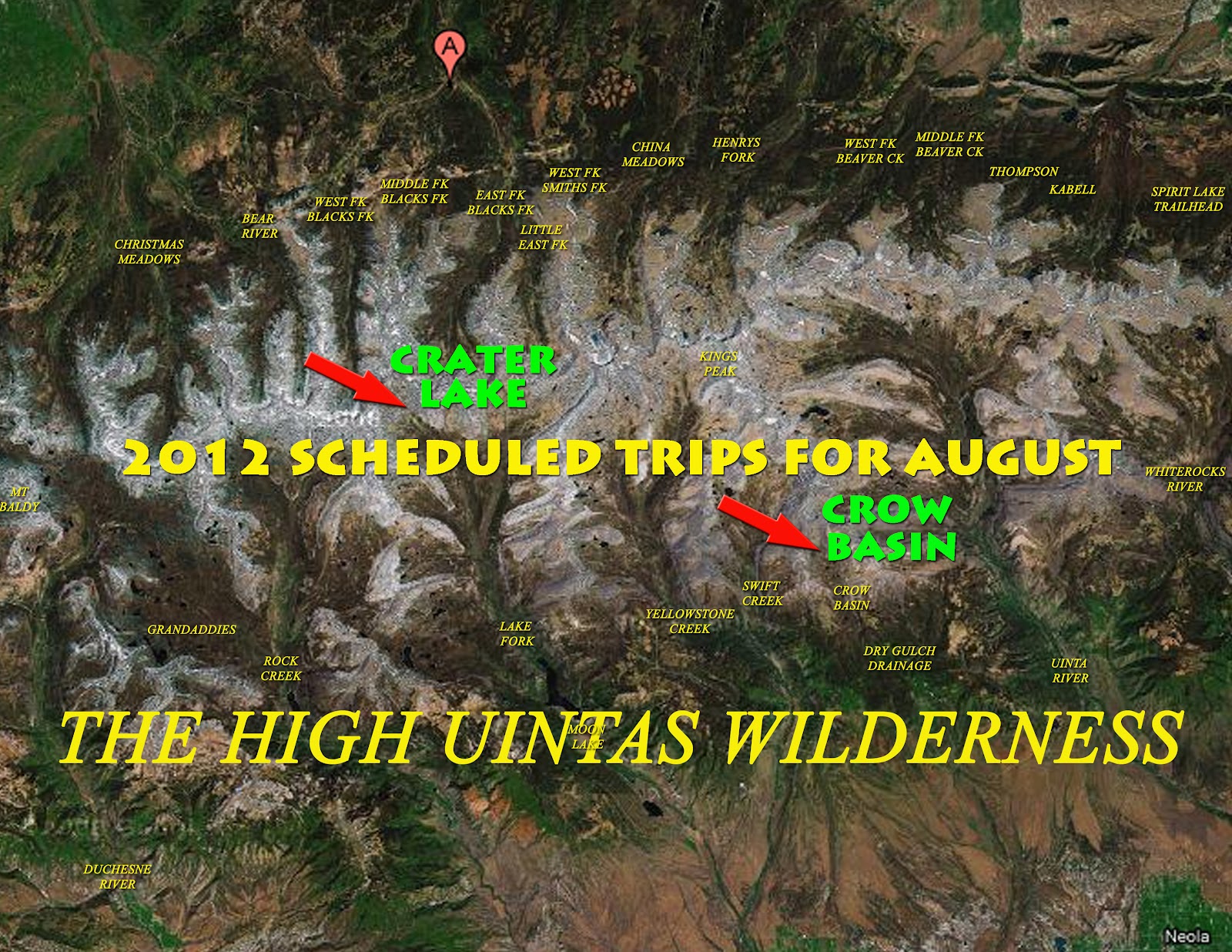
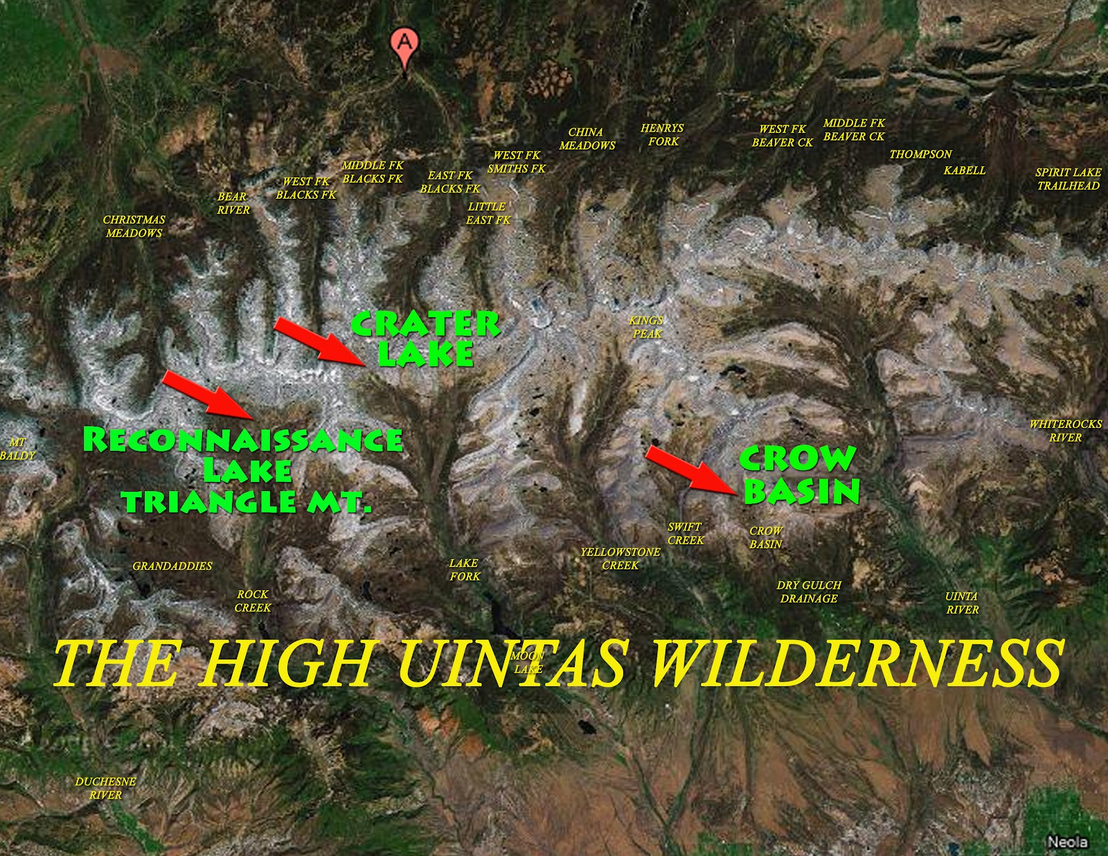
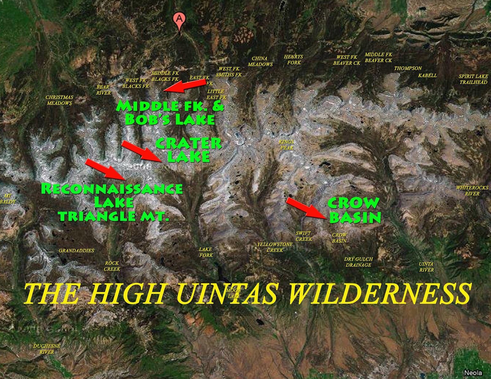
First up let’s take a quick glance at the 4 trips I plan on taking during the month of August,. I’m waiting until August this summer as there will be fewer mosquitoes, the weather will most likely be better, and the streams low and more easily forded. Of course I’m still dealing with my High Uintas Wilderness Project, so the trips will be in the Uintas.
The trips will not necessarily be taken in the order we outline here–in fact the last one will for sure be the first backpack taken to begin the season. Here we begin with the one that is impressive due to having wonderful aerial photographs. from Jonathan Jaussi–thanks, Jonathan.
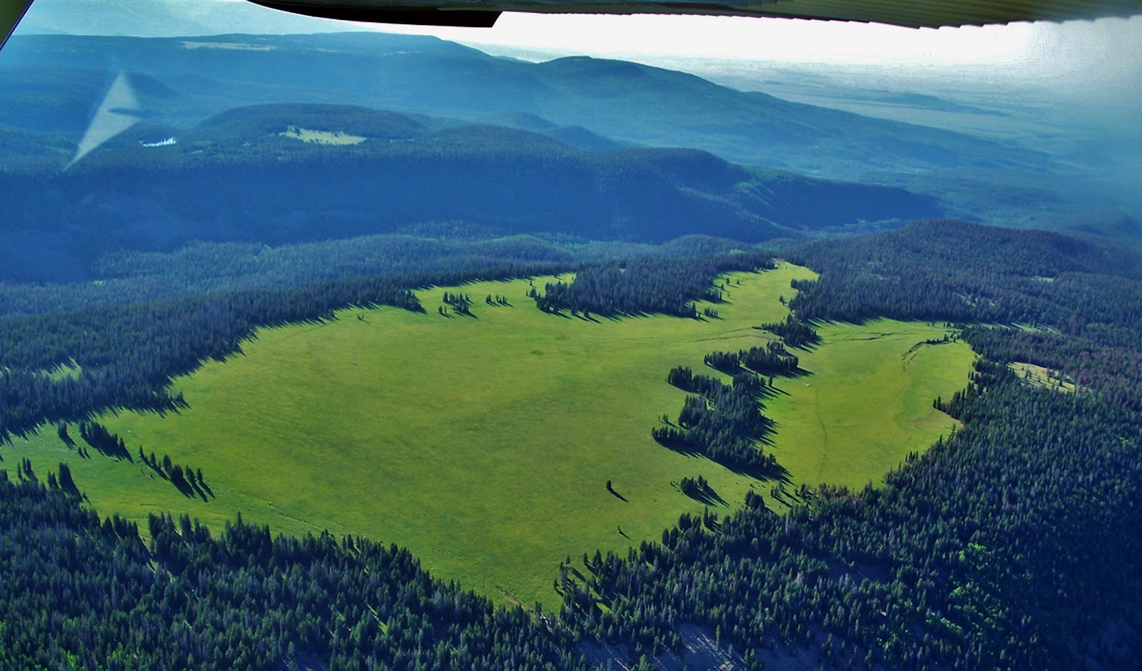
Crow Basin is part of the Dry Gulch Drainage, the smallest in the High Uintas. It is sandwiched between the Yellowstone and Uinta River Canyons on the South Slope. The view above is looking north up Crow Canyon with12,194 ft. high Flathead Mountain on the right, and Mt. Emmons dominating the scene. Emmons is the 4th highest peak in Utah and the Uintas, at 13,440 ft. Following that ridge to the left you come to 13,387 ft. Mt.Jedediah, 5th highest, and eventually Utah’s highest, Kings Peak. at 13,528 ft.
Above we are looking south down Crow Canyon seeing some of the 9-10 lakes in the basin that have fish.
Here we are moving to the west seeing above to the right Jackson Park. Right in the center of this photograph is the escarpment I got to last year which kept me from going down into the basin. Along this same escarpment to the left, or south, you get to areas of pines and aspens where perhaps one could get down into the canyon although very steep and rocky.
From up the ridge we look south towards beautiful Jackson Park.
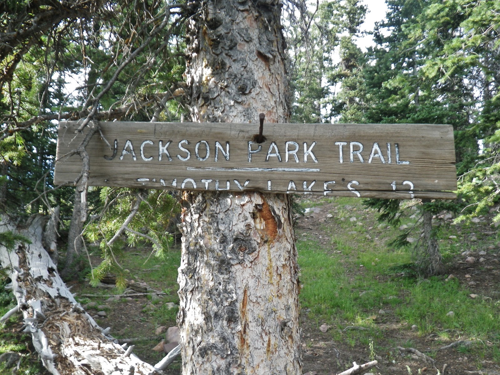
We are moving towards the west looking southeast and if you look closely to the right of the pines that divide the right quarter, you can see a fine line that is the trail coming out of the pines where is found the only sign in the area I insert below. (NOTE: If you can’t see said trail, click on the image to enlarge.) That trail continues up into the Swift Creek drainage, then forks, the trail going north west climbs 11,613 ft. Bluebell Pass, the right fork takes you to the Timothy and Carrol Lakes a distance of 13 miles.
This sign is next to the only spring in the area. Last year I camped near here.
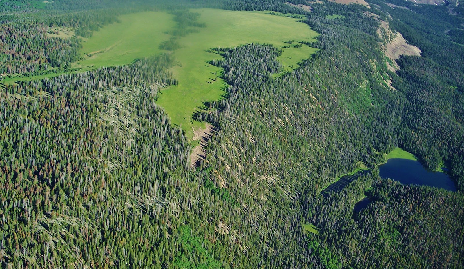
Now we have moved around to the southwestern edge of the Park. In the middle is where I found the only water in the area that comes from a spring at the edge of the second grouping of pines.
We’re looking at Jackson Park from the south with Crow Canyon on the right. Possibly a good pathway down into the canyon is from the far southern point of the park in the lower middle of this photograph, and from there swing up the canyon to the basin.
I will likely first attempt getting down into the canyon from this southern part of Jackson Park.
Another of my priority trips is to Crater Lake a truly exotic area I’ve never seen a picture of in any of the guide books. You can come up Lake Fork from Moon Lake on the South Slope, a gradual elevation gain hike of around 20 miles.
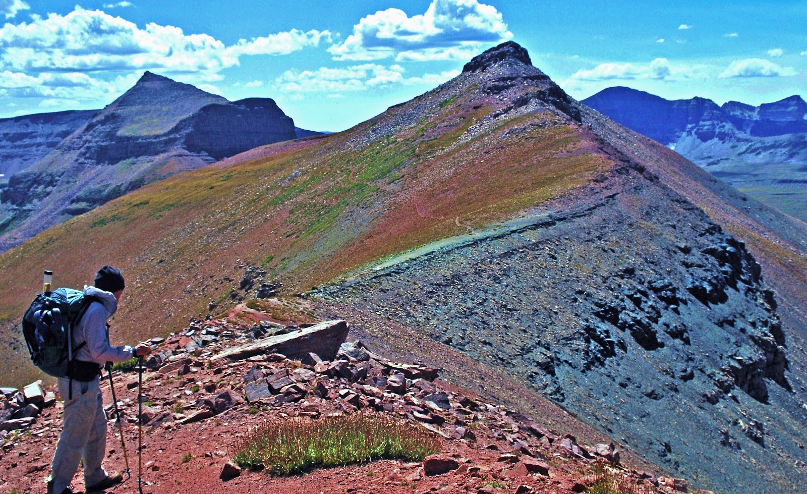
A shorter, but a much more adventurous and spectacular route of 16 miles is from the East Fork of Blacks Fork Trailhead on the North Slope. In the upper reaches you climb 12,165 foot high East Fork Pass (my name) with 13,219 foot high Mt. Lovenia dominating the scene.
Here I am coming from Mt. Lovenia, with the trail (and pass) to the left.
My buddy, Ted Packard is looking from East Fork Pass towards Red Knob. You can see faintly the trail along the slopes of Red Knob winding its way towards the pass along the spine of the High Uinta Mountains. You actually go down 465 ft. in elevation to get to Red Knob Pass.
We are now on 11,700 ft. Red Knob Pass looking towards the Dead Horse area at the head of the West Fork of Blacks Fork on the North Slope. We will follow the Higfhline Trail to the left down into the South Slope’s Lake Fork Drainage.
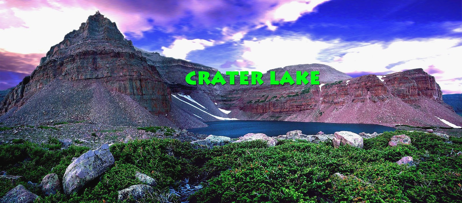
Now on the South Slope in the Upper Lake Fork Drainage’s arctic tundra we see our objective in the middle of the photograph–Explorer Peak in the dead center at whose base in a glacial cirque is Crater Lake. Once switch-backing down from Red Knob Pass you go off-trail but as you can see it’s easy hiking.
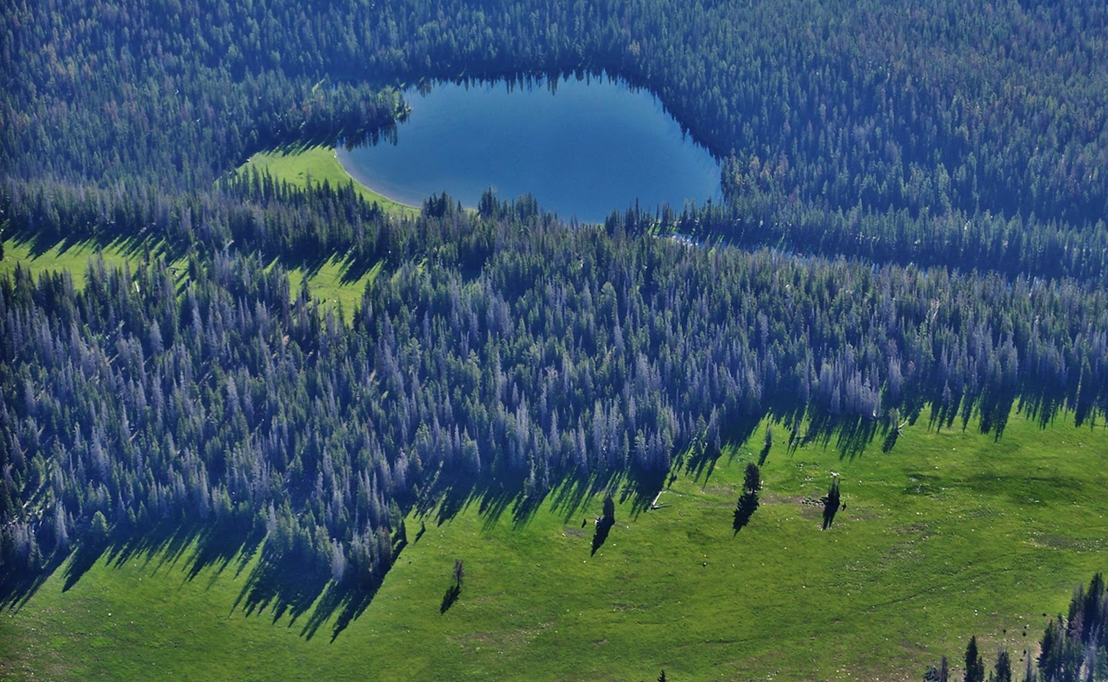
Here we are at one of the jewels of the Uintas–its deepest lake at 147 feet. For years I have yearned to get up on the ridge to the north, or right, and bivouac there to attempt getting a spectacular wide angle photograph of the lake and Explorer Peak. This trip will likely be the last of the summer, and depending on how I’m doing, I might just go from here east towards Porcupine Lake and Pass, even climbing the pass to test the unnamed lakes above North Star Lake in the Garfield Basin, then backtrack to Squaw pass and the alpine lakes of Little East Fork of Blacks Fork, where Bigfoot has been reported seen more than in any other area. From there back to the Trailhead. That could be more than I can chew, but we’ll see……stay tuned.
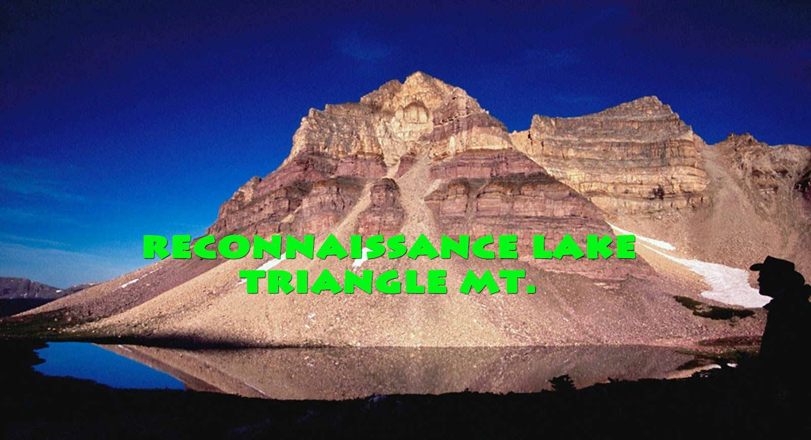
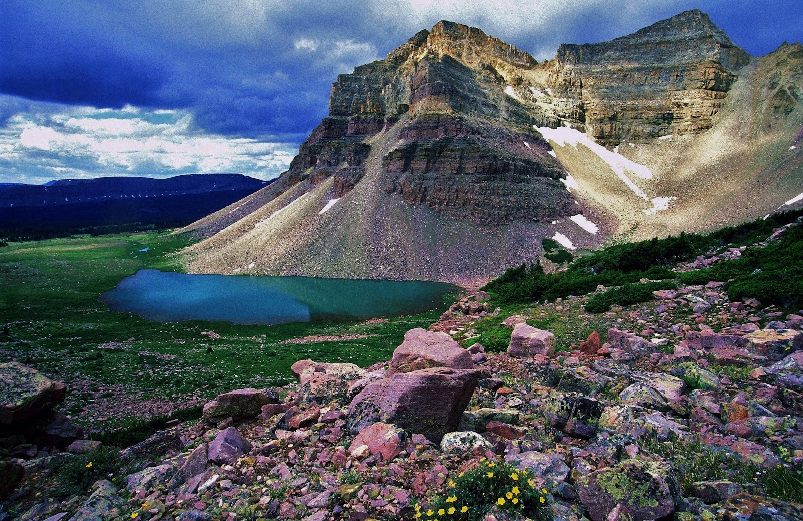
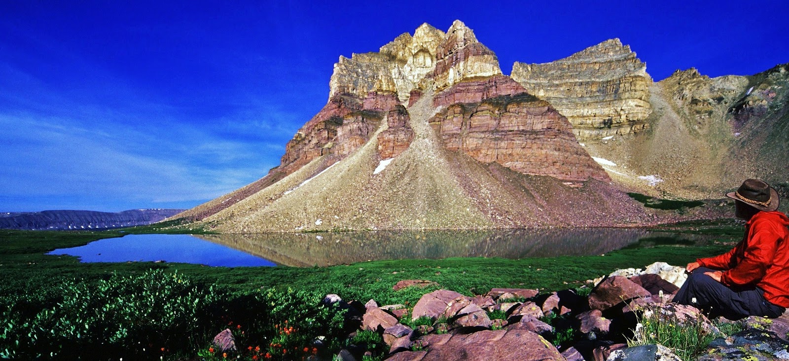
The 3rd backpack will be to the off-trail Reconnaissance Lake and Triangle Mt. area at the head of the Rock Creek Drainage. Access is from the Highline Trailhead on the Mirror Lake Scenic Byway. The hike leads you up over Rocky Sea Pass and east to the Rock Creek Drainage. I will follow the above timberline trail that circles the far reaches testing the waters of several remote lakes and on to Reconnaissance Lake–about 20 miles from the Trailhead.
For me this beautiful alpine scene rivals Red Castle as the most beautiful mountain scene in Utah.
Triangle Mountain is 12,385 feet high, with the lake above timberline at around 11,150 feet elevation.
I have been to this area 3 times, but love it so much that I hope to be able to make it one more time before considering hanging up my backpack.
While in this wonderful area I will attempt a few extras, like, climbing the saddle to the east to get photographs far below of Allsop Lake and the East Fork of the Bear River on the North Slope–such as was done by my friend Doug Perry and his boys a few years ago. From here I will also get back on the trail and follow it east to Ledge Lake and continue towards Dead Horse Pass, detouring off trail briefly to get improved photographs of Continent Lake (you can see what I’ve got on my “1000 Mile Whirlwind Backpack in the High Uintas “)
The 4th area we will enjoy seeing here, but which will actually be my first backpack of the season, is to little visited and mysterious North Slope’s Middle Fork of Blacks Fork, part of my purpose being the pursuit of greater understanding of the “unsung American heroes” the TIE HACKERS, without which the West wouldn’t have been won. Pretty bold statement, right?
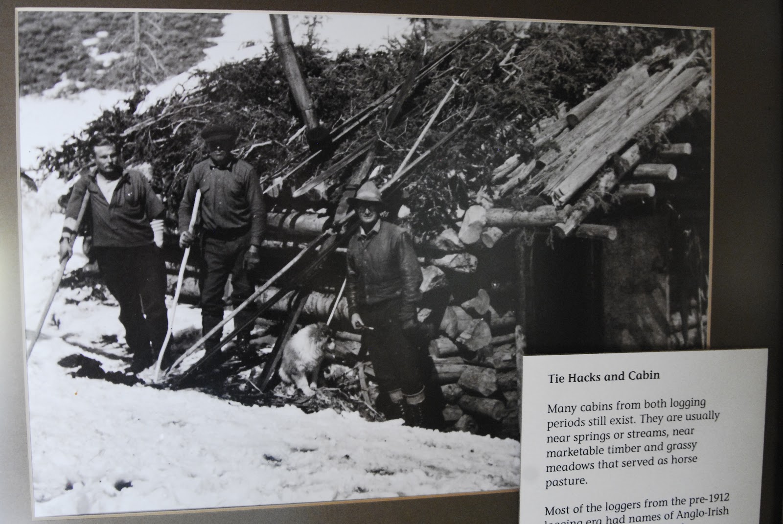
For those who don’t know what the heck I’m talking about, permit me to give a very brief explanation. Above we see a tie hack cabin moved piece by piece from the Steele Creek area and put back together at the Mt. View Ranger Station to the north in Wyoming.
In 1867 the Transcontinental Railroad was being constructed to the north of the Uintas in Wyoming and millions of railroad ties were needed.
Rugged Irish immigrant lumbermen were sent into the Uinta’s North Slope, and other areas to work 12 months a year making railroad ties with their broadaxes.
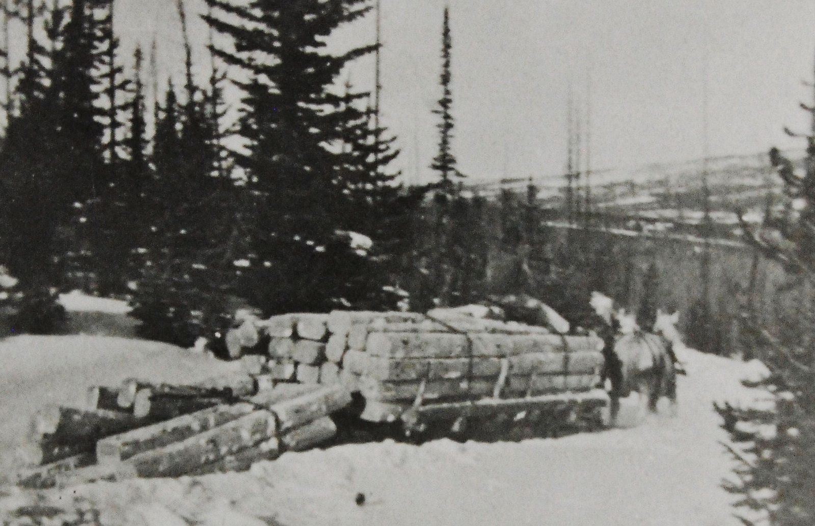
Much of their work was done in the winter time when they could more easily transport the ties using sleds.
They were accumulated in the river and creek beds behind what they called “splash dams.” When the thaw came and the lakes behind these temporary dams filled up the dams were blown with dynamite and the ties were washed or “splashed” downstream into Wyoming where they were picked up by the railroad.
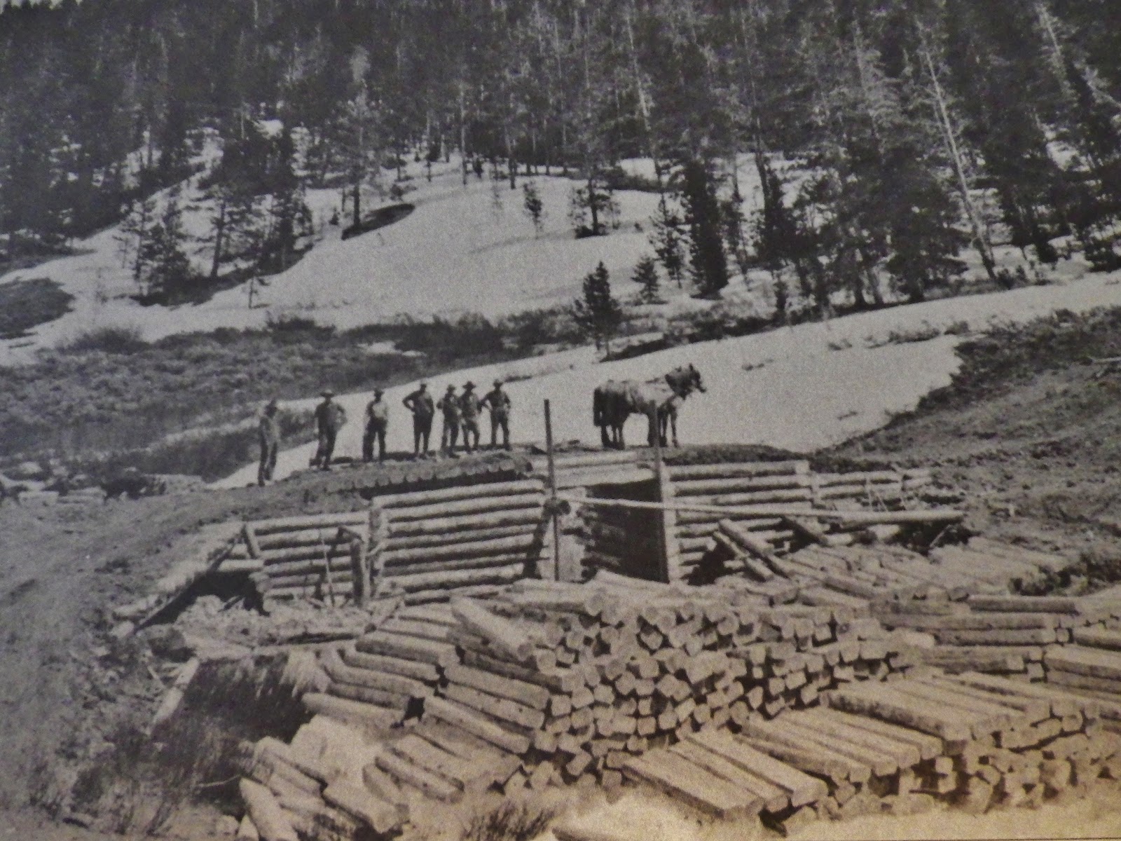
These tough tie hackers built their cabins, and small communities in the lodgepole areas of the Uinta’s North Slope.
The area where I have found and photographed the most ruins is an area that is never mentioned in any of the books, scientific studies, and Forest Service reports. It is the little visited beautiful Middle Fork of Black’s Fork that leads to 13,165 ft. Tokewanna Peak. This will be my 3rd trip into the area. This trip, among other purposes, is to begin getting my mountain legs and lungs in shape–acclimatizing myself for higher and more difficult elevations.
For the first couple of days I will be at elevations between 9,000 and 10,000 feet crisscrossing back and forth across the canyon mapping and photographing all the sites, and dating all of them–either from the early 1867-1880 period, or the 1912-1935 period.
I’m just showing 2 sites here of the dozen or so I have found and photographed. The one above was quite large and possibly a dinning hall, also used by the tie hackers for dances and social gatherings.
That task accomplished, and hopefully acclimatized, as in recent years I have experienced some High Altitude Sickness, I will then move up the canyon towards Tokewanna Peak and Bob’s Lake.
Bob’s Lake is on the right side of the ridge coming off the peak. Three smaller lakes are found in the drainage to the left of the ridge.
Bob’s Lake will be my first objective in the high country. Three years ago I caught very strong Tiger Trout, and I would hope that they are still alive and much larger. From Bob’s Lake I will climb the ridge to the east, or left, and drop over into another branch of the canyon.
In this area there are three small lakes, two of which possibly have fish and I will test them and report.
Unless you are a young buck that has kept yourself in good shape with a lot of physical activity, you’d better be willing to work real hard at getting in shape. Hiking with a load on your back above 10,000 feet is no cake walk–in fact the stress is multiplied several times over normal hiking. If you are in your 77th year, such as will be the case with me, you have to do much, much more.
For three years I have persisted in having a job that is the perfect job for me to have a chance at being in shape. Some have called my job “the lowest in the food chain” but I have found that going on an hour walk three times a week has me going downhill. I need much more, and in my job as a “shopping card herder” I do around 7 miles 4 times a week, half of it pushing long chains of carts, jumping at the chance of doing all the heavy lifting possible with customers, and I’m known for jogging a lot to help a customer with purchases, or go get a stray cart.
Of course that’s only a part of the need. The rest I do at home putting a pack on my back and getting hours in while watching Utah Jazz games, and other things on TV. Right now, in April I’m doing it with a 50 lb. pack. That will increase up to 65 pounds as the backpacking season approaches. I also do 40 to 60 push ups during time-outs as seen in the YouTube video.
Some of you might remember what happened last season. I took 2-1/2 months off from my work to have one heck of a backpack summer.
My first trip was a bust as everything was still snowed in. I drove around, took photographs, checked with the Forest Service, and did YouTube videos reporting conditions, but didn’t get any exercise.
The 2nd and 3rd trips and weeks were pretty much the same. Trailheads snowed in, roads washed out, and bridges down. The high country was inaccessible like I had never seen before. The forest Service recommended waiting until August.
I finally was able to get to a Trailhead and go backpacking, but found that a month of inactivity had really hurt me. When you’re older you lose your conditioning much faster, and have a much harder time getting it back. Being out of shape produced a domino effect–not just phsical weakness, but also my weakened condition had High Altitude Sickness slow me down.
Having a tough time, I weakened in more ways than one, and dreamed of Forest Gump running around the country for 3 years, having accumulated a following, when he all of a sudden stopped turned around and was about to speak. Someone yelled out, “Quiet he’s going to say something!” He did, saying,
I came to that conclusion too, thinking “I’m finished!”
That was after my survival experiences on the trail to Garfield Basin, and again at Jackson Park frin where I headed down the trail with a terrific thunder storm bearing down on me all the way. I moved pretty good and did the 6 miles in record time. Pretty soon, reflecting on how well I did and felt, I recalled how I’ve preached, “NEVER GIVE IN!”
So I concluded I was far from finished. I just had to keep working, working out, and next summer work right up to the day before I put on my pack for my first backpack.
Then I will be wise with that first trip and gradually get used to the extreme stress of high altitude hiking with weight on my back and keep pecking away at my scheduled trips, one by one and do the best I can, but with a foundation of hard work, and feeding my body properly as will be outlined in Part 2.
So tune in to Part 2 that will be coming in a week or so.
VIDEO #9 Part 1: BACKPACKING PREPARATION and 2012 SCHEDULE
This is the first of 3 parts to help us be able to have a great, successful, safe and even inspiring 2012 backpack season……and many more on into the future. Each YouTube video will be followed by what I call “photo/essays” that some might just call “articles.” They will be as I have done with subjects such as:
These photo/essays will follow the same outline as the videos, using the same photographs, perhaps more information in the text, and the advantage of links to related subjects on the website, to more detail on the internet, and to all items recommended where you can instantly purchase at prices usually lower than you can get anywhere else.
Part 1: PREPARE–2012 Schedule and Getting in Shape to Accomplish the Goals
Part 2: Overcoming Obstacles with Good Nutrition and Supplements
Part 3: Backpacking Equipment and Gear–what I will be using and newest gear.
This is a photo/essay of a 2009 road trip seeking tie hacker sites accessible by car. I just noticed (July 31, 2012) that the program was somehow lost. I am restoring the photographs and will from memory write quickly new captions and explanations. When I have a little more time on my hands I will go back to my research and describe more fascinating details of the places visited during this trip of discovery.
THE TIE HACKERS OF THE HIGH UINTAS NORTH SLOPE
The tie hackers were Irish lumbermen immigrants sent in 1867 into the Uintas to work 12 months a year making millions of railroad ties with their broad axes for the Transcontinental Railroad being constructed north of the Uintas in Wyoming.
We begin the search in Mt. View, Wyoming, one of the “Gateways to the High Uintas,” at a tie hacker cabin located at the Ranger Station. This cabin was carefully taken apart at Steel Creek on the Uinta’s North Slope and put back together here.
We begin the search at the Ranger Station.
We see in the cabin one of their broad axes with which they made millions of railroad ties.
At the Ranger Station I was able to photo copy the only reports available on the tie hackers which are all from the modern tie hack period–1912 to about 1940. The early period from 1867 to around 1880 was prior to the organization of the Forest Service, and almost no original, first-hand information is available.
I insert here the title pages of several of the reports.
From the Ranger Station in Mt. View I backtracked to Fort Bridger State Park to see if I could find any information about the tie hackers.
I found no references to the tie hackers, but nonetheless was fascinated by what I learned about the early history of the area. From there I returned to Mt. View and visited the Public Library.
The visit was very fruitbul jotting down references to one book on the tie hackers, noted below, which I thereafter acquired.
Also I found a reference to a DVD which also was subsequently purchased.
The personnel were most helpful and we found several other references related to the tie hackers, the first being the ghost town of PIEDMONT, located west of Mt. View.
Of great interest I also learned of one of the early towns the tie hackers and railroad men had established near the Bear River about 30 miles north of the Utah border. It was called Bear Town, and described as “one of the liveliest, if not the most wicked town in America.” It only lasted 2 years and then quickly disappeared like Sodom and Gomorrah after occurred there the “bloodiest battle between whites in the history of Wyoming!”
It was easy to continue my search heading west looking for Piedmont and Bear Town.
Soon I was on a gravel road seeing a wind farm to the north, then left the green ranch lands winding my way through sagebrush country and in another few miles came over a rise to view in the distance the Piedmont area.
Soon the charcoal kilns of Piedmont and ruins of the ghost town appeared.
The ghost town lies on private land with No Trespassing signs posted, except at the kilns that can be visited. The town is tied to the tie hackers as they provided the wood burned in the kilns to produce charcoal.
Eventually coal mining made charcoal obsolete. The community had a boarding house, saloon, general store and post office and was used by soldiers from Ft. Bridger for their time off and weekends.
Moses Byrne established the community that originally was an Overland Stage Station. Many of the residents were from Moses extended family.
This was most likely the school house.
From the road you look acrossed the stream at the Cemetery that is accessible to the public. I photographed all the tombstones, and will insert here a few. The birth and death dates often are very telling of the difficulty of pioneer life.
Here we are looking back at the road.
This isn’t it, but the last person buried in the cemetery was in 1998 and signs of flowers placed on graves were present. One of these years I will spend my Memorial Day there and see who I can meet and what I can learn about the community.
I wanted to find Bear Town, but didn’t have enough information, nor time. Later you will notice I did find the site and found some artefacts, and by that time learned much more about the fascinating story of this fabled place.
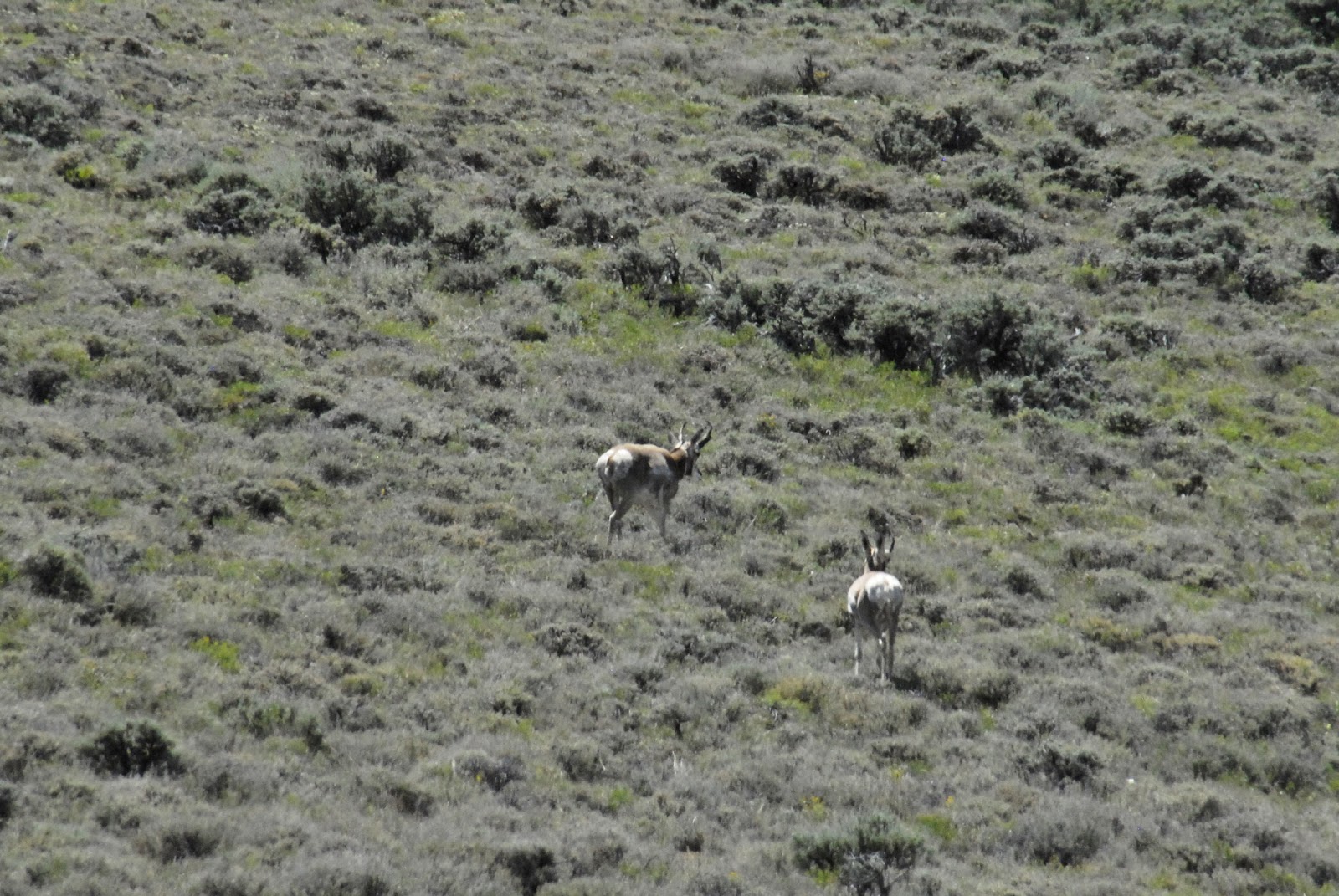
So I turned south and headed for the Uintas seeing along the way a few antelope, and treaded ground where many years ago were found herds of American Bison. Bones of these unique mammals have been found in North Slope canyons.
We drive south from Mt. View crossing Wyoming ranch lands and the band of sagebrush country that surrounds the High Uintas.
Right on the Wyoming-Utah border we find a secluded little spot called “Suicide Park.” This represents one of the sadly darker sides of the tie hack culture. The tie hacks worked a very hard and sometimes solitary life and often didn’t have many family ties.
When they grew older they often began having a very difficult, if not impossible, time carving out enough railroad ties to support themselves. At Suicide Park three tie hacks are buried who just couldn’t take it any longer and took their own lives.
A Forest Service placard tells briefly their story. They are all from the modern period of the Tie Hack Culture–1912-1940.
Eventually when I finish my research and exploration and put this whole story together I will tell in more detail the story of these three.
For now I’ll only show one of the stone markers. You will notice the name is not Irish. The tie hackers from the 20th century, rather than being Irish as in the early period, were rather Scandinavian, mostly Swedish.
I might add, now in 2012 when I’m doing my best to put together again this 2009 story, Suicide Park has deteriorated greatly and needs to be rebuilt.
We now have driven a few miles north to the North Slope Road and are heading east towards the Hewinta Guard Station road (not marked, but is the first that goes south once you pass Steel Creek). I show the Hewinta Guard Station in the First tie hack photo/essay where I met Teresa and Bob and began learning about the fascinating tie hack culture.
Steel Creek is found between the East Fork of Blacks Fork and the West Fork of Smith’s Fork. Up this creek is found the ruins of the Steel Creek Commissary–a tie hack site from the modern period. To get to it you take the Hewinta Guard Station road and shortly veer to the right on usually a muddy road that takes you soon to the site.
Here we see debris, such as the old shot up stove seen to the right, that shows this is a site from the 1912-1940 period.
Here we see what for me has been a rarity at tie hack sites, an outhouse turned on its side. Below I’ll zoom in.
Zoomed in we see the seat and hole of the outhouse.
This is the filled up outhouse hole.
Here we see the crude lid for the hole.
We now leave the Steel Creek Commisary ghost and head west on the North Slope Road. NOTE: Up the road from the Hewinta Guard Station, just a mile or so from here, you come to the West Fork of Smiths Fork Trailhead. Up that trail (and old road) are some incredible tie hack sites you can see in the First photo/essay.
On the rough, often deeply rutted logging road from Steel Creek to the East fork of Black’s Fork there are several tie hack cabins along the road. you see one here. Usually this stretch of the North Slope Road requires a 4 x 4 vehicle.
We have now traveled another 5 miles west and have driven up the West Fork of Blacks Fork to fish a little, bag some more beautiful wildflowers and camp for the night.
We zoom up the canyon to witness the scars from a forest fire, and glimpse the northern side of Mt. Beulah.
A beautiful morning. Up the West Fork are a number of tie hack sites which we won’t be able to get to this trip. We’ll get to them another year.
Hungry brook trout were plentiful.
We are now back on the North Slope Road heading west towards the Mirror Lake Scenic Byway. If you keep a sharp lookout a number of tie hack ruins can be seen on the south side of the road.
As we drive west up out of West Fork of Black’s Fork canyon, we get a glimpse of 13, 165 foot high Tokewanna Peak, one of the 7 named 13,000 + peaks in the Uintas.
Up Mill Creek we greet a pair training for the St. George Marathon.
At Mill Creek we see remnants of one of the tie hacker’s splash dams where they would accumulate their ties during the winter and then with the spring runoff would blow the dam and let the flood carry their ties north into Wyoming where they would be picked up by the Union Pacific Railroad.
We have now returned to the pavement and the Mirror Lake Scenic Byway stopping for a brief visit at the Bear River Ranger Station.
This is a great place to stop to get a drink of ice cold water, use the restrooms and buy postcards and High Uintas related maps, books and pamphlets.
Out back you don’t want to miss visiting the tie hack cabin, also from the Steel Creek Commissary. Inside are wonderful displays telling the Tie Hack Story.
Our last stop going up the Mirror Lake Scenic Byway, we pull onto the Whitney Road just 50 yards or so and see this display that will be the objective of several exploratory trips over the ensuing years.
TO SEE THIS YouTube VIDEO CLICK ON THE IMAGE BELOW
The video slide show begins with a couple of incredible aerial photographs of Crow Basin and Jackson Park, taken by friend Jonathan Jaussi (soon I’ll do a post of all his wonderful collection in preparation to conquer the area in August 2012). Thanks, Jonathan.
To give you a glimpse of over 140 varieties photographed–around 40 new, I’ve put them all into a fast moving YouTube video slide show 12 minutes long. There’s no sound, nor attempt to identify them–yet. I will work on that during the long winter to ward off “cabin fever” and then do the big job of updating the wildflower albums in the Galleries section with THE BEST OF THE BEST–likely bringing the total varieties to around 280. In most cases I try and show the entire plant, then zoom in.
If you enjoy the presentation, or any others on the website, a small donation would help keep the effort going.
WHAT FOR 2012 (besides the Mayan end of the world!)?
The “Forest Gump Moment” mentioned in my last trip report was only momentary. On that trip to Jackson Park and Crow Basin (YouTube video) I did so well doing the 6 miles to the car that I’m convinced I’m far from finished. So I’m now back in training at REAMS SUPERMARKET, in Springville to be ready for 4 trips in August of 2012. Drop by the store at 759 E. 400 South– I’d love to serve you while keeping in shape. I’m grateful for that opportunity to serve, and appreciative of the management and owners for giving me a job that literally helps keep me alive and raring to go in the Uintas and I’m even planning on running again (15th time) in 2012 the Coban International Half Marathon in Guatemala.
If you want to know other details about what keeps me moving (and I promise it will do the same for you), click on:
Note: Supplements and anything you purchase from Amazon by clicking on my links, earn a small commission for the High Uintas Project, and you’ll get them cheaper and fast.
INTERESTED IN KNOWING WHAT FOUR TRIPS?
1. CROW BASIN
2. MIDDLE FORK OF BLACKS FK–tie hacker exploration and Bob’s Lake/Tiger trout
3. TRIANGLE MOUNTAIN/RECONNAISSANCE LAKE and CONTINENT LAKE
4. CRATER LAKE/EXPLORER PEAK via East Fork and Red Knob Passes
When working hard on the trail the fatigue you experience, sometimes coupled with getting a little wet in the rain, and especially coupled with advancing years, will lower your resistance and might bring on a debilitating cold. To ward it off, and/or get better quicker I have always recommended ZICAM Cold Remedy, but recently a new product has appeared that I feel is more effective, and half the price. It is calledCOLD-EEZE, pictured below. NOTE: You can get this cheaper at the pharmacy or supermarket than on Amazon.
Don’t wait to start sucking on them until you are sick, but do so at the first suspicion of maybe it happening and immediately start taking also the increased dose of Wellness capsules explained above. In most cases you will avoid getting sick, or if you start a bit late, you will get over it much quicker. This will be the cheapest through the above link.
TO SEE THIS YouTube VIDEO CLICK ON THE IMAGE BELOW
The video slide show begins with a couple of incredible aerial photographs of Crow Basin and Jackson Park, taken by friend Jonathan Jaussi (soon I’ll do a post of all his wonderful collection in preparation to conquer the area in August 2012). Thanks, Jonathan.
To give you a glimpse of over 140 varieties photographed–around 40 new, I’ve put them all into a fast moving YouTube video slide show 12 minutes long. There’s no sound, nor attempt to identify them–yet. I will work on that during the long winter to ward off “cabin fever” and then do the big job of updating the wildflower albums in the Galleries section with THE BEST OF THE BEST–likely bringing the total varieties to around 280. In most cases I try and show the entire plant, then zoom in.
If you enjoy the presentation, or any others on the website, a small donation would help keep the effort going.
WHAT FOR 2012 (besides the Mayan end of the world!)?
The “Forest Gump Moment” mentioned in my last trip report was only momentary. On that trip to Jackson Park and Crow Basin (YouTube video) I did so well doing the 6 miles to the car that I’m convinced I’m far from finished. So I’m now back in training at REAMS SUPERMARKET, in Springville to be ready for 4 trips in August of 2012. Drop by the store at 759 E. 400 South– I’d love to serve you while keeping in shape. I’m grateful for that opportunity to serve, and appreciative of the management and owners for giving me a job that literally helps keep me alive and raring to go in the Uintas and I’m even planning on running again (15th time) in 2012 the Coban International Half Marathon in Guatemala.
If you want to know other details about what keeps me moving (and I promise it will do the same for you), click on:
Note: Supplements and anything you purchase from Amazon by clicking on my links, earn a small commission for the High Uintas Project, and you’ll get them cheaper and fast.
INTERESTED IN KNOWING WHAT FOUR TRIPS?
1. CROW BASIN
2. MIDDLE FORK OF BLACKS FK–tie hacker exploration and Bob’s Lake/Tiger trout
3. TRIANGLE MOUNTAIN/RECONNAISSANCE LAKE and CONTINENT LAKE
4. CRATER LAKE/EXPLORER PEAK via East Fork and Red Knob Passes
This was sort of a teaser introduction for the article written by the
Tribune’s Outdoor Editor, Brett Prettyman, and published on Oct. 4, 2011.
Thanks, Brett, for doing a great job reporting on the High Uintas Project.
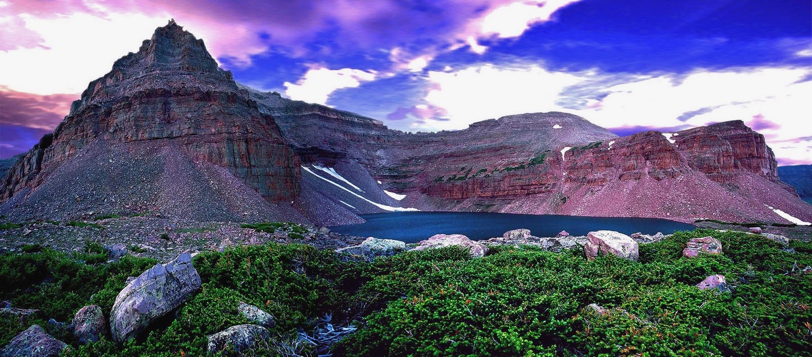
Apparently they changed the format of this section printing horizontally filling the whole page with the panorama of what some think is the most beautiful mountain scene in Utah–Triangle Mountain and Reconnaissance Lake (see it full screen and high definition at the end of this post–in several versions from dawn to twilight). It is off-trail in the remote upper Rock Creek drainage of the Uinta’s South Slope and as far as I can tell has never been published before. I’ll show it, and all the 13 photos from the online version of the article, but include descriptions of each, and insert the magnificent record wild trout caught from some of them. Click on the link below to go to the article, and then come back to see the photo album with detailed captions, Comments, and Survival discussion.
In the newspaper version they printed two black and white photographs, which follow in full color: NOTE: Click on the photos to enlarge
The Tribune’s caption: Cordell Andersen takes in the beauty of Red Castle Peak in the High Uinta Mountains. Below, Andersen enjoys a meal near Kings Peak.
My comment: If you saw the black and white versions printed in the newspaper you will understand why the book I envision on the High Uintas must have mostly color photographs.
Now to the set of online photographs with captions and a handful of critical additions:
Here I am crossing the arctic tundra of the upper Lake Fork drainage in mid-September when it turned into the survival experience mentioned in the article. Click on that if you want to learn the details. As mentioned when up at 12,165 ft. on the ridge in the background and in need I had a satellite phone and I was talking to Russ Smith from Skycall Satellite who “called in the cavalry.”The cost was covered by my insurance and my 10% deductible payment. I mention that as there were related negative comments in the Tribune’s online version. Scroll down to see them.
Before continuing my review of the photos from the online Tribune article, let’s insert something else to set the stage for those who aren’t sure where the High Uinta Mountains are and how extensive. First a Google Earth view showing the Uintas in relation to the Wasatch front/Salt Lake City, Wyoming on the north, and Colorado to the east–this is impressive even for those of us who know the Uintas.
Below we zoom in on just the Uinta Mountain Range–actually the Wilderness Area, the light portions indicating the above timberline/arctic tundra areas which you can see are very extensive–only beat by the San Juan Mountains of Colorado.
Now to the Tribune’s photo album of my photographs.
This was the Tribune’s first of the online album. It is actually quite unattractive unless you know some detail. Their caption is: Beard Lake in the High Uinta Mts. .Let me tell you the rest of the story. This alpine lake is near 11,769 ft. Trail Rider Pass, 20 miles from the nearest trailhead, between the Lake Atwood Area and the Painter Basin–all part of the Uinta River drainage. Above it is a no-name 13,247 ft. peak I call Beard Peak. To our right are the slopes of the 13,387 ft. mountain I have named Mount Jedediah which I’ll get to in a moment. Here, in what some maps designate as lake U-74, a giant hooked jawed Eastern Brook trout you see below grabbed my Thomas Cyclone.
This brookie’s body descends down into transparent water about 3 feet deep. I let him swim around while getting out my tripod for a good picture of what I knew for sure was a new Utah State record by several pounds, but then he was gone. So we’ll never know for certain but his length was estimated at between 24 and 30 inches which would have had him weigh from 9 to 11+ lbs. The Utah State record brookie weighed 7.5 lbs. from the Boulder Mountains. Whatever his weight might have been this brookie shows that the Uintas don’t have to play second fiddle to any other place in America. Click on the following link for a discussion on the world record brook trout.
This is a little different version of the same picture in the Tribune album, composed and used by the High Desert Museum of Bend, Oregon for one of its displays.
My caption for this picture in my Lightweight Backpacking article refers to my 27 day expedition. It is: Pumped up on the 11th day heading for Crater Lake. Equipment and food weight down to around 67 lbs. with a much stronger body. Believe me that doing this was about the most invigorating thing I have ever done in my life. But, no matter what your age, you shouldn’t attempt this without proper training and planning. Remember I trained for it for years, jogging daily, running half-marathons, and 2-3 times a week hiking 4 miles around the rolling hills of my farm in Guatemala with a 100 lb. bag of fertilizer on my back. Without this I would have never been able to do what I did–and enjoy it. If you’re not willing to pay the price, don’t attempt anything similar. In the center of the image is Explorer Peak and in a glacial cirque at its foot is found Crater Lake you see below.
Beautiful Crater Lake, the Uinta’s deepest at 147 ft., is another of the most inspiring spots in the Uintas, but which again is not shown in any of the books on the Uintas. I still have the vision of the ultimate photo of this scene being taken from the ridge on the right with a wide angle lenscapturing the lake and Explorer Peak. I still hope to bivouac up there for that “perfect shot.”
From the deepest, we go here to the largest lake in the High Uintas, Grandaddy Lake, one of the 26 lakes in the Grandaddy Basin, with well known mountains in the background: From the left, Mt. Baldy, Hayden Peak, Mt. Agassiz, and Spread Eagle Peak.
With winter approaching in mid-September I got this panorama of the backbone of the High Uintas from 12,165 ft.* East Fork Pass (my name) at the head of the East Fork of Blacks Fork, with 13,219 ft. Mt. Lovenia out of sight far to our left, then Red Knob, in the distance to the right Mt. Beulah, and last at the edge of the image the slopes of 13,165 ft. Tokewanna Peak. *Note:Previously on my website I stated that East Fork Pass was 12,300 ft. but I have corrected myself.
Here I’m viewing at sunset Utah’s highest mountain, 13,528 ft. high Kings Peak. One of my captions for this scene is: KINGS PEAK as the setting sun turned it to gold, so far the only gold I have found in the High Uintas. This photograph was taken on the “survival backpack” as explained a bit further along and in the BACKPACK LIGHT and SURVIVAL segment where the image of my bivouac camp is also featured.
Down the ridge south of Kings Peak we come to Mt. Jedediah that guards no-name U-75 lake where on my 27 day expedition I caught the large brook trout seen below. The 13,387 ft. high mountain, 5th highest in Utah, was (unofficially) named by me for who I think was the most outstanding of the explorers and mountain men of the west, Jedediah Smith. In my Crow Basin trip report I added about him: Smiths Fork, born in the Red Castle area on the North Slope, is also named in honor of Jedediah Smith, who along with his men first trapped the North Slope in the 1820’s. “Diah” as he was sometimes affectionately called was a giant among those early explorers different in that he carried (and read) his Bible, did not swear, nor drink and refused to have to do with women of ill repute.
11,130 ft. high East Red Castle Lake guarded by the multiple Red Castle Peaks was also another of those remote lakes that produced larger than normal native cutthoroat trout as you see below.
Another heavy bodied native cutthroat trout from East Red Castle Lake.
Young Rocky Mountain Goat on East Grandaddy Mountain. For photographs of most of the Animals of the Uintas, click on that link. Go to the GALLERIES page to see Mountainscapes, Wildflowers, Origen and Rocks, Uinta Friends, etc.
This shot will have to represent the continually growing collection of wildflowers. As soon as I have time to update the Gallery album with the new varieties I’ve photographed the total will likely surpass 250.
The Tribune article also mentioned my exploration and research on the “tie hackers,” without whom the West wouldn’t have been won. My 7 photo essays on them can be represented by the opening page of one of them seen below. Links to all of them can be found on my Articles page.
There is some exciting and fascinating history related to these incredibly tough guys who worked 12 months a year in the Uintas. Check out the reports, one of which is represented below in a 1867 photograph of one of their ghost towns–Beartown, described as “the liveliest, if not the most wicked town in America.” It grew to 2,000 people in 2 years and then disappeared like Sodom and Gomorrah. I found the exact spot as seen in the photograph below. This relatively unknown story will be part of my book.
We now come to the full page spread in the Tribune article.
We end where we started with this beautiful scene of Triangle Mountain and Reconnaissance Lake. I will not hang up my backpack until I can experience live one more time this incredibly inspiring corner of God’s great creation. Below see other views from daylight till twilight.
An unforgettable dawn.
In my 3 visits to the area I’ve never seen another human being and always had a truly wonderful wilderness experience.
Going alone seems to be an issue with some–and it should be. I don’t advise it with anyone, unless they can meet my criteria which I explain in the next few paragraphs. Links to get more detail are highlighted. In the ARTICLES section of my website I have a category called Survival articles, in which I explain the important precautions I take every time I go on a trip. Check out the 7 experiences and be prepared to LIVE.
Even if you understand all those experiences and the principles involved, I’ll have to admit that it still isn’t a good idea to go alone–but, if you must because of being stubborn, or sort of dense–I guess like me, be aware of the precautions I take, and do the same or better.
First, I let family and friends know exactly where I’m going and leave with themcopies of the topographical route maps and my daily schedule (click on that link and check out 3 photo views to see what I mean). In recent years this is outlined on my website on the Schedule page, with links for each trip to the topographical route maps. Click on those links to see what I’m talking about.
Second, I was a Medical Corpsman in the Army and then upgraded to Medical Specialist. I then lived for 37 years in the backcountry of Guatemala where I performed thousands of emergency treatments each year, even minor surgery, so with that training, background and experience, plus knowledge of my body, I go prepared for nearly any possible emergency. Once again my survival and Lightweight Backpacking articles mention the essentials, including the right kind of clothes, rain gear, and attitude, including faith.
Third, as mentioned I always have a satellite phone which I encourage every group to have, and anyone who goes alone. Until the emergency mentioned in the Tribune article it had only been used twice for emergencies in nearly 5 years. Those were when I loaned it to Scout groups with serious problems.
Any time I make an important deviation from my schedule I call and advise. On my 27 day expedition I called the family every night at a designated time. At that time in 2003 there didn’t exist yet the SPOT Tracker, mentioned next. Remember you can rent a sat phone and SPOT Tracker from Russ Smith at Skycall Satillite.
Fourth, I always have with me my SPOT Personal Satellite Tracker. Before leaving I program it on my computer for the trip I’m taking, including an OK message to email daily to 10 on my list. With that email they can click on the link and go to Google Earth and see exactly where I started and where I’m camped each evening. I also leave what they call a “bread crumb trail” that can be accessed from the SPOT website using the link I put on my website, available to all for each trip and emailed also to all my High Uinta Friends.
NOTE: So you can see what I mean I’ll program the SPOT Tracker now that you can access by clicking on this LINK Note: The link was only good as I describe next for 7 days. For this demonstration it took you to my home in Springville and area with a breadcrumb trail. That is what you saw if you clicked during the first week.What shows now is when I went on the deer hunt and used the SPOT where I camped that night. So you can see what I mean I’ll insert below a photo of my SPOT tracks from my last trip to Jackson Park and Crow Basin. NOTE: In doing this demonstration I found that the SPOT Tracker will work through the glass of your windshield .
The SPOT is also programmed with a Help message to be sent to 4 special friends with special info like health issues, etc. With that message the 4 friends would have to take action, and they would know exactly where I was. Then of course there is the 911 button that triggers Search and Rescue showing them exactly where to go.
Get a SPOT Tracker cheaper than anywhere, and earn a commission for the High Uintas Project.
Last of all, as shown in my last YouTube Video (#7), and in the photo above, if I leave my pack I always clip the SPOT Tracker to my belt so it can be easily accessed in case of emergency. That survival story is told in more detail in the photo/essay of that name.
The pessimist, or fearful, might say that even having all the emergency gadgets you might be in trouble having a heart attack, slipping and hitting your head on a rock, falling into a ravine or whatever, and not be able to use your SPOT Tracker. Of course all those things, or equivalents, could happen to you every time you leave your home, or even in your home. Having and using a SPOT Tracker every day in the wilderness will at least show where you were yesterday, if not heard from today, and that combined with a trip plan of where you were to head next will make the search relatively easy.
From this season I also had another survival YouTube video that isVideo #4: Survival at Swasey Hole that one viewer called “genius.” I’m not sure why……. guess I’ll have to look at it again.
This discussion isn’t over without mentioning Eric Robinson, the 64 year old Australian lost in the Uintas and never found this past season (2011). He had a Personal Locator Beacon but never used it. It obviously worked out being a mistake for him to go alone ( in my opinion, UNPREPARED), so of great importance it’s worth repeating that he apparently didn’t take any of the precautions I take. I use my SPOT tracker several times each day–at least assuring those interested where I was yesterday giving them a good starting point and hopefully avoiding waiting 7 years to get the insurance money!
Just follow the simple rules and have a wonderful time in the great outdoors–and make the wait for those at home relaxing, worry free and fun knowing each day you’re still in the game and you’ll be home soon.


.JPG)
.JPG)


.jpg)